IMAGES TAKEN NEAR TO
Low West Avenue, ROWLANDS GILL, NE39 1EA
Introduction
This page details the photographs taken nearby to Low West Avenue, NE39 1EA by members of the Geograph project.
The Geograph project started in 2005 with the aim of publishing, organising and preserving representative images for every square kilometre of Great Britain, Ireland and the Isle of Man.

There are currently over 7.5m images from over14,400 individuals and you can help contribute to the project by visiting https://www.geograph.org.uk
Image Map
Images are licensed for reuse under creativecommons.org/licenses/by-sa/2.0
Notes
- Clicking on the map will re-center to the selected point.
- The higher the marker number, the further away the image location is from the centre of the postcode.
Image Listing (5 Images Found)
Images are licensed for reuse under creativecommons.org/licenses/by-sa/2.0
Image
Details
Distance
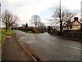
1
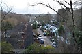
Dene Avenue in Rowlands Gill, Gateshead
All quiet on the first morning of the new year 2017.
Image: © Andrew Tryon
Taken: 1 Jan 2017
0.01 miles
2
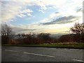
Smailes Lane, Highfield
Looking south across the Derwent Valley to Pontop Pike.
Image: © Robert Graham
Taken: 12 Dec 2012
0.15 miles
3
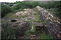
Beehive Coke Ovens
The scheduled remains of the last beehive coke ovens to work in the Durham coalfield. 1861-1958. They ceased to work before I was born!
Image: © Chris Allen
Taken: 5 Jul 1995
0.20 miles
4
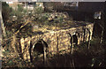
Rowlands Gill - Whinfield coke ovens
The scheduled remains of the last working beehive coke ovens in the country. Built in 1861 and worked until 1958. There were 193 on this site and 5 + two halves have been preserved. A scheduled Ancient Monument since 1975 and restored in the 1980s. These are well-hidden and unloved although quite sound when seen in 1999.
Image: © Chris Allen
Taken: 14 Mar 1999
0.21 miles
5
Strathmore Road
In the Highfield area of Rowlands Gill.
Image: © Robert Graham
Taken: 12 Dec 2012
0.24 miles