IMAGES TAKEN NEAR TO
Alwin, WASHINGTON, NE38 9EL
Introduction
This page details the photographs taken nearby to Alwin, NE38 9EL by members of the Geograph project.
The Geograph project started in 2005 with the aim of publishing, organising and preserving representative images for every square kilometre of Great Britain, Ireland and the Isle of Man.

There are currently over 7.5m images from over14,400 individuals and you can help contribute to the project by visiting https://www.geograph.org.uk
Image Map
Images are licensed for reuse under creativecommons.org/licenses/by-sa/2.0
Notes
- Clicking on the map will re-center to the selected point.
- The higher the marker number, the further away the image location is from the centre of the postcode.
Image Listing (5 Images Found)
Images are licensed for reuse under creativecommons.org/licenses/by-sa/2.0
Image
Details
Distance
1
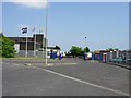
Entrance to SP Tyres factory
Formerly Dunlop Tyres. Closure of the factory (due to inability to compete with far east imports) was announced in April 2006. 450 people are to be made redundant later in 2006.
Image: © Brian Abbott
Taken: 7 Jun 2006
0.20 miles
2
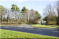
Road junction at Vigo Lane
The junction is effectively a staggered crossroads. Rickleton Way is in the foreground, Vigo Lane is opposite and it continues behind the camera position.
Image: © Trevor Littlewood
Taken: 22 Feb 2022
0.22 miles
3
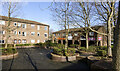
Flats and shops at centre of Rickleton
A tarmacked area with raised, brick-built shrubbery beds at the centre of the development in Rickleton
Image: © Trevor Littlewood
Taken: 22 Feb 2022
0.23 miles
4

Former mineral railway
Once this was a railway serving coal mines and is shown as such on a 1980 1:50,000 map. Now it is part of the Coast to Coast cycle route.
Keep following the Route 7 signs and you will end up in Inverness!
Image: © Richard Webb
Taken: 18 Jun 2013
0.23 miles
5

The last stage
Two heavily-laden cyclists on the last leg of the world-famous C2C cycle route from the Irish Sea in West Cumbria to the North Sea at Sunderland. Here the route follows the line of an old railway (the Consett and Sunderland path) through Washington New Town.
Image: © Oliver Dixon
Taken: 19 Jun 2015
0.23 miles