IMAGES TAKEN NEAR TO
Dalamere Close, WASHINGTON, NE38 9DH
Introduction
This page details the photographs taken nearby to Dalamere Close, NE38 9DH by members of the Geograph project.
The Geograph project started in 2005 with the aim of publishing, organising and preserving representative images for every square kilometre of Great Britain, Ireland and the Isle of Man.

There are currently over 7.5m images from over14,400 individuals and you can help contribute to the project by visiting https://www.geograph.org.uk
Image Map
Images are licensed for reuse under creativecommons.org/licenses/by-sa/2.0
Notes
- Clicking on the map will re-center to the selected point.
- The higher the marker number, the further away the image location is from the centre of the postcode.
Image Listing (4 Images Found)
Images are licensed for reuse under creativecommons.org/licenses/by-sa/2.0
Image
Details
Distance
1
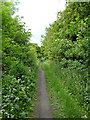
Bridleway from Chartershaugh to General's Wood
Following what appears to be the line of an old road in the south-west corner of Washington.
Image: © Oliver Dixon
Taken: 19 Jun 2015
0.07 miles
2
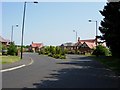
The entrance to High Generals Wood estate
An upmarket housing estate built in the last 2 / 3 years.
Image: © Brian Abbott
Taken: 7 Jun 2006
0.10 miles
3
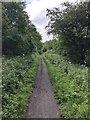
Bridleway from Bonemill Lane adjacent to The General's Wood
Bridleway from Bonemill Lane adjacent to The General's Wood. Facing south-east, the General's Wood is on the near side.
Image: © Victor Deanes
Taken: 22 Jun 2020
0.10 miles
4
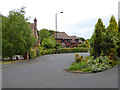
Bramhall Drive, General's Wood
The "posh" end of Washington.
Image: © Oliver Dixon
Taken: 19 Jun 2015
0.23 miles