IMAGES TAKEN NEAR TO
Rowan Avenue, WASHINGTON, NE38 9AQ
Introduction
This page details the photographs taken nearby to Rowan Avenue, NE38 9AQ by members of the Geograph project.
The Geograph project started in 2005 with the aim of publishing, organising and preserving representative images for every square kilometre of Great Britain, Ireland and the Isle of Man.

There are currently over 7.5m images from over14,400 individuals and you can help contribute to the project by visiting https://www.geograph.org.uk
Image Map
Images are licensed for reuse under creativecommons.org/licenses/by-sa/2.0
Notes
- Clicking on the map will re-center to the selected point.
- The higher the marker number, the further away the image location is from the centre of the postcode.
Image Listing (5 Images Found)
Images are licensed for reuse under creativecommons.org/licenses/by-sa/2.0
Image
Details
Distance
2
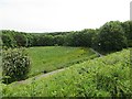
Park, Washington
Semiwild area as often found in new towns. View from a railway embankment across the Biddick Burn. The former mineral line is now a cycle path.
Image: © Richard Webb
Taken: 18 Jun 2013
0.20 miles
3
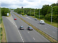
Washington Highway
The Washington Highway (A182) is the main south-north highway through Washington New Town. The slip roads lead down to a roundabout (out of sight) at the intersection with the west-east Western Highway/ Northumberland Way (A195). Seen from a bridge on the Consett and Sunderland railway path which follows a green corridor from west to east across the southern part of Washington.
Image: © Oliver Dixon
Taken: 19 Jun 2015
0.20 miles
4
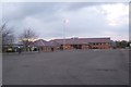
St Robert of Newminster RC School
The only Catholic secondary school in Washington. It is a mixed school and also has a sixth form.
Image: © hannah barrett
Taken: 11 Apr 2006
0.20 miles
5
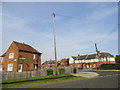
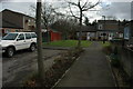
Maplewood Crescent, Harraton
Off Vigo Lane, in the centre of the village.
Image: © Robert Graham
Taken: 5 Sep 2014
0.20 miles