IMAGES TAKEN NEAR TO
New Road, WASHINGTON, NE38 9AP
Introduction
This page details the photographs taken nearby to New Road, NE38 9AP by members of the Geograph project.
The Geograph project started in 2005 with the aim of publishing, organising and preserving representative images for every square kilometre of Great Britain, Ireland and the Isle of Man.

There are currently over 7.5m images from over14,400 individuals and you can help contribute to the project by visiting https://www.geograph.org.uk
Image Map
Images are licensed for reuse under creativecommons.org/licenses/by-sa/2.0
Notes
- Clicking on the map will re-center to the selected point.
- The higher the marker number, the further away the image location is from the centre of the postcode.
Image Listing (5 Images Found)
Images are licensed for reuse under creativecommons.org/licenses/by-sa/2.0
Image
Details
Distance
1
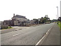
Restaurant on Bonemill Lane
Amiro's restaurant in Harraton. This building looks as if was a pub at one time.
Image: © Robert Graham
Taken: 5 Sep 2014
0.08 miles
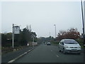
3
Looking west up Vigo Lane, Harraton
Harraton is a village east of Birtley, now part of Washington.
Image: © Robert Graham
Taken: 5 Sep 2014
0.19 miles
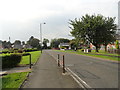
4
The entrance to High Generals Wood estate
An upmarket housing estate built in the last 2 / 3 years.
Image: © Brian Abbott
Taken: 7 Jun 2006
0.21 miles
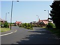
5
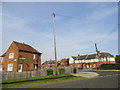
Maplewood Crescent, Harraton
Off Vigo Lane, in the centre of the village.
Image: © Robert Graham
Taken: 5 Sep 2014
0.24 miles