IMAGES TAKEN NEAR TO
Pinewood Close, WASHINGTON, NE38 8QR
Introduction
This page details the photographs taken nearby to Pinewood Close, NE38 8QR by members of the Geograph project.
The Geograph project started in 2005 with the aim of publishing, organising and preserving representative images for every square kilometre of Great Britain, Ireland and the Isle of Man.

There are currently over 7.5m images from over14,400 individuals and you can help contribute to the project by visiting https://www.geograph.org.uk
Image Map
Images are licensed for reuse under creativecommons.org/licenses/by-sa/2.0
Notes
- Clicking on the map will re-center to the selected point.
- The higher the marker number, the further away the image location is from the centre of the postcode.
Image Listing (13 Images Found)
Images are licensed for reuse under creativecommons.org/licenses/by-sa/2.0
Image
Details
Distance
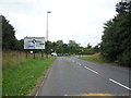
2
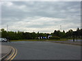
Roundabout on Pattinson Road at the end of Staithes Road
Image: © Alexander P Kapp
Taken: 25 May 2011
0.07 miles
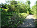
3
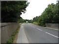
Pattinson Road
Looking north west from the disused railway bridge towards the A195.
Image: © JThomas
Taken: 18 Aug 2018
0.13 miles
4
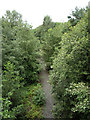
Path on disused railway, Washington
View from the bridge on Pattinson Road.
Image: © JThomas
Taken: 18 Aug 2018
0.15 miles
5
Washington 1st railway station (site), Tyne & Wear
Opened in 1835 by the Stanhope & Tyne Railway, eventually part of the North Eastern Railway, on the line from Durham Turnpike (Chester-le-Street) to South Shields. This station became a junction in 1840 but was largely replaced by the more conveniently sited 2nd Washington station (see Image) in 1850, when the main line was diverted towards Newcastle. It lingered on until 1853 with a market-day train, and then closed.
View north east towards the 2nd Washington station, South Shields and Newcastle. The track through here was lifted in 2012 and nature was re-establishing itself. No trace of the station appears to exist.
For more information, see http://www.disused-stations.org.uk/w/washington_first/index.shtml
Image: © Nigel Thompson
Taken: 29 May 2021
0.17 miles
6
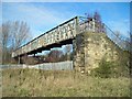
Sturdy footbridge
Built over a disused railway. With the railway no longer in use, will it survive or get cleared away?
(This footbridge crossed a number of railway lines at the south end of the former Washington Station - see http://www.disused-stations.org.uk/w/washington_second/index.shtml for the history of this line and pictures of the station before and after closure in 1963.)
Image: © Antony Dixon
Taken: 6 Mar 2012
0.17 miles
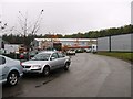
7

Asda Distribution Centre, Washington
Seen looking across waste land from the C2C cycle route near the James Steel Park.
Image: © Oliver Dixon
Taken: 19 Jun 2015
0.18 miles
8
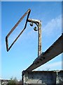
Lamp bracket on footbridge
A nice bit of hand-made iron work, but does it have a future?
Image: © Antony Dixon
Taken: 6 Mar 2012
0.18 miles
9
Pattinson Road Roundabout
Junction with the A195.
Image: © JThomas
Taken: 18 Aug 2018
0.20 miles