IMAGES TAKEN NEAR TO
Faraday Close, WASHINGTON, NE38 8QJ
Introduction
This page details the photographs taken nearby to Faraday Close, NE38 8QJ by members of the Geograph project.
The Geograph project started in 2005 with the aim of publishing, organising and preserving representative images for every square kilometre of Great Britain, Ireland and the Isle of Man.

There are currently over 7.5m images from over14,400 individuals and you can help contribute to the project by visiting https://www.geograph.org.uk
Image Map
Images are licensed for reuse under creativecommons.org/licenses/by-sa/2.0
Notes
- Clicking on the map will re-center to the selected point.
- The higher the marker number, the further away the image location is from the centre of the postcode.
Image Listing (16 Images Found)
Images are licensed for reuse under creativecommons.org/licenses/by-sa/2.0
Image
Details
Distance
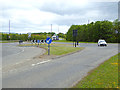
1
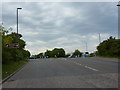
Pattinson Road as it approaches the roundabout with Alston Road
Image: © Alexander P Kapp
Taken: 25 May 2011
0.07 miles
2
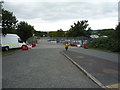
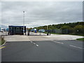
Entrance to car auctions site off Pattinson Road
Image: © JThomas
Taken: 18 Aug 2018
0.11 miles
3
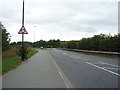
Pattinson Road
Looking south west towards the roundabout.
Image: © JThomas
Taken: 18 Aug 2018
0.15 miles
4
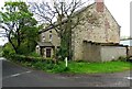
Former farmhouse
The mid 19th century farmhouse at Middle Barmston. No longer used as such.
Image: © Robert Graham
Taken: 9 May 2023
0.15 miles
5
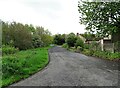
Top of Barmston Lane
At the junction with Madarin Way. The lane leads past Middle Barmston Farm here and down to the Washington Wetland Centre.
Image: © Robert Graham
Taken: 9 May 2023
0.16 miles
6
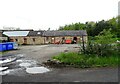
Old farm buildings at Middle Barmston
Middle Barmston farm is an old Victorian farmstead which is now used by Washington Wetland Centre. No longer a working farm, these outbuildings would originally have been stables and cattle byres.
Image: © Robert Graham
Taken: 9 May 2023
0.16 miles
8
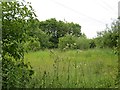
Woodland off Barmston Lane
Land left to go wild in Washington.
Image: © Richard Webb
Taken: 18 Jun 2013
0.19 miles
9
Roundabout on Pattinson Road
At the industrial east side of Washington.
Image: © Oliver Dixon
Taken: 19 Jun 2015
0.19 miles
10
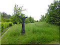
National Cycle Network milepost near Washington Westland Centre
The National Cycle Network is marked at intervals by specially designed mileposts donated to the project by the Royal Bank of Scotland. This example stands beside the world-famous C2C cycle route. There are four designs - one each by an Englishman, a Welshman, a Scotsman and an Irishman. The example seen here on the left is an "English" one, entitled "the Fossil Tree" and designed by John Mills. The arms indicate Fatfield 2 miles and Consett 17 miles to the left and Stadium of Light 3 miles and Sunderland City Centre 5 miles to the right.
Image: © Oliver Dixon
Taken: 19 Jun 2015
0.19 miles