IMAGES TAKEN NEAR TO
Garrigill, WASHINGTON, NE38 8PQ
Introduction
This page details the photographs taken nearby to Garrigill, NE38 8PQ by members of the Geograph project.
The Geograph project started in 2005 with the aim of publishing, organising and preserving representative images for every square kilometre of Great Britain, Ireland and the Isle of Man.

There are currently over 7.5m images from over14,400 individuals and you can help contribute to the project by visiting https://www.geograph.org.uk
Image Map
Images are licensed for reuse under creativecommons.org/licenses/by-sa/2.0
Notes
- Clicking on the map will re-center to the selected point.
- The higher the marker number, the further away the image location is from the centre of the postcode.
Image Listing (25 Images Found)
Images are licensed for reuse under creativecommons.org/licenses/by-sa/2.0
Image
Details
Distance
2
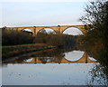
The Victoria Viaduct
"An impressive and dramatic railway viaduct spanning the River Wear on ten arches, near Fatfield. It was based on the Roman bridge at Alcantara, in Spain, and was opened in 1838 on the day of Queen Victoria's Coronation. The bridge linked the Durham Junction Railway with the industrial and commercial districts on the north and south sides of the river." (from Sunderland C.C. website)
Image: © Alan Fearon
Taken: 19 Nov 2005
0.17 miles
3
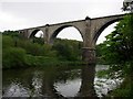
Victoria Viaduct over the River Wear
Opened in 1838. The main arch has a span of 160 feet (about 48 metres) and is the largest masonry railway arch in England. The line was closed to passengers in 1963. It was used for freight until finally being closed in 1991. Still, remarkably, in good condition.
(More information on the history of the railway line and of the Washington station nearby can be found at http://www.disused-stations.org.uk/w/washington_second/index.shtml )
Image: © Brian Abbott
Taken: 14 May 2006
0.17 miles
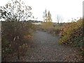
5
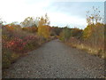
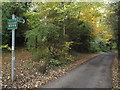
Dismantled railway line near Washington
This was the route of the original main line between London and Newcastle-upon-Tyne, opened in 1838. The main line was rerouted through Durham in 1872, but this line remained in use with passenger services continuing until 1964. Freight trains continued to run until 1991.
The tracks have now been lifted, leaving the ballast as a reminder that trains once ran here.
Image: © Malc McDonald
Taken: 29 Oct 2016
0.18 miles
6
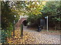
C2C cycle route near Washington
The C2C (coast-to-coast) is a long-distance cycle route crossing the north of England. Here, it passes under a disused railway line near Washington, in Tyne & Wear.
Image: © Malc McDonald
Taken: 29 Oct 2016
0.19 miles
7
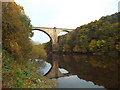
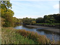
River Wear near Washington
A disused railway viaduct crosses the River Wear near Washington.
Image: © Malc McDonald
Taken: 29 Oct 2016
0.19 miles
8
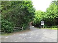
Car park off Shepherd Way
James Steel Park, Washington.
Image: © Richard Webb
Taken: 18 Jun 2013
0.19 miles
9
Dismantled railway near Washington
This is the original route of the railway line between London and Newcastle-upon-Tyne, opened in 1838. Although the main line was rerouted via Durham in 1872, this line continued in use until 1964 for passenger trains, and 1991 for freight.
The tracks have now been lifted, but the ballast remains.
Image: © Malc McDonald
Taken: 29 Oct 2016
0.19 miles
10
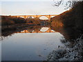
Victoria Viaduct over the River Wear
The viaduct was built to carry the main London - Newcastle railway.
Image: © Chris Jackson
Taken: 30 Nov 2008
0.19 miles