IMAGES TAKEN NEAR TO
Railway Terrace, WASHINGTON, NE38 8LZ
Introduction
This page details the photographs taken nearby to Railway Terrace, NE38 8LZ by members of the Geograph project.
The Geograph project started in 2005 with the aim of publishing, organising and preserving representative images for every square kilometre of Great Britain, Ireland and the Isle of Man.

There are currently over 7.5m images from over14,400 individuals and you can help contribute to the project by visiting https://www.geograph.org.uk
Image Map
Images are licensed for reuse under creativecommons.org/licenses/by-sa/2.0
Notes
- Clicking on the map will re-center to the selected point.
- The higher the marker number, the further away the image location is from the centre of the postcode.
Image Listing (11 Images Found)
Images are licensed for reuse under creativecommons.org/licenses/by-sa/2.0
Image
Details
Distance
2
Looking over to Penshaw Monument
Image: © gordon james brown
Taken: 26 Jun 2011
0.13 miles
3
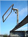
Lamp bracket on footbridge
A nice bit of hand-made iron work, but does it have a future?
Image: © Antony Dixon
Taken: 6 Mar 2012
0.15 miles
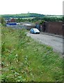
4
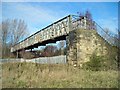
Sturdy footbridge
Built over a disused railway. With the railway no longer in use, will it survive or get cleared away?
(This footbridge crossed a number of railway lines at the south end of the former Washington Station - see http://www.disused-stations.org.uk/w/washington_second/index.shtml for the history of this line and pictures of the station before and after closure in 1963.)
Image: © Antony Dixon
Taken: 6 Mar 2012
0.18 miles
5
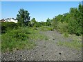
Washington 2nd railway station (site), Tyne & Wear
Opened in 1850 by the York, Newcastle & Berwick Railway, soon to be part of the North Eastern Railway, this station replaced an earlier one some 600m behind the camera position. In turn, this one closed in 1963.
View north towards Usworth and Newcastle, also to Boldon and South Shields. The last track through here was lifted in 2012.
For more information, see http://www.disused-stations.org.uk/w/washington_second/index.shtml
Image: © Nigel Thompson
Taken: 29 May 2021
0.18 miles
6
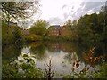
Reservoir at Swan
Houses on Station Road and Lakeside Gardens reflected in the water of the reservoir at Swan
Image: © Antony Dixon
Taken: 25 Oct 2011
0.19 miles
7
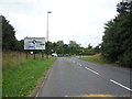
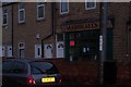
Pattinson Road Roundabout
Junction with the A195.
Image: © JThomas
Taken: 18 Aug 2018
0.20 miles
8
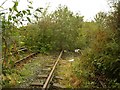
Railway lines crossing Station Road
View along the railway where it crosses the Station Road bridge (see also Image)
Just south of the bridge was the site of Washington Station, closed to passengers in 1963. Information on the history of this line and photos of the station before and after closure can be found at http://www.disused-stations.org.uk/w/washington_second/index.shtml
Image: © Antony Dixon
Taken: 25 Oct 2011
0.21 miles
9
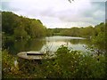
Willows Reservoir, Swan
The circular structure in the foreground is marked on the OS map as a well.
The lake is also used for fishing.
Image: © Antony Dixon
Taken: 25 Oct 2011
0.21 miles
10
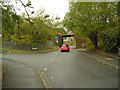
Station Road railway bridge (Pattinson side)
. . . with Station Road/Wilden Road junction
Image: © Antony Dixon
Taken: 25 Oct 2011
0.22 miles