IMAGES TAKEN NEAR TO
Horsley Road, WASHINGTON, NE38 8HW
Introduction
This page details the photographs taken nearby to Horsley Road, NE38 8HW by members of the Geograph project.
The Geograph project started in 2005 with the aim of publishing, organising and preserving representative images for every square kilometre of Great Britain, Ireland and the Isle of Man.

There are currently over 7.5m images from over14,400 individuals and you can help contribute to the project by visiting https://www.geograph.org.uk
Image Map
Images are licensed for reuse under creativecommons.org/licenses/by-sa/2.0
Notes
- Clicking on the map will re-center to the selected point.
- The higher the marker number, the further away the image location is from the centre of the postcode.
Image Listing (5 Images Found)
Images are licensed for reuse under creativecommons.org/licenses/by-sa/2.0
Image
Details
Distance
1
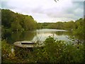
Willows Reservoir, Swan
The circular structure in the foreground is marked on the OS map as a well.
The lake is also used for fishing.
Image: © Antony Dixon
Taken: 25 Oct 2011
0.18 miles
2
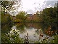
Reservoir at Swan
Houses on Station Road and Lakeside Gardens reflected in the water of the reservoir at Swan
Image: © Antony Dixon
Taken: 25 Oct 2011
0.24 miles
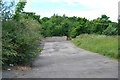
4
Station Road railway bridge (Pattinson side)
. . . with Station Road/Wilden Road junction
Image: © Antony Dixon
Taken: 25 Oct 2011
0.25 miles
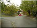
5
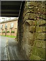
Station Road railway bridge (detail)
I love the way the stonework of this modest little bridge has been angled to allow people to walk by without stepping into the road
Image: © Antony Dixon
Taken: 25 Oct 2011
0.25 miles