IMAGES TAKEN NEAR TO
Duxbury Park, WASHINGTON, NE38 8BJ
Introduction
This page details the photographs taken nearby to Duxbury Park, NE38 8BJ by members of the Geograph project.
The Geograph project started in 2005 with the aim of publishing, organising and preserving representative images for every square kilometre of Great Britain, Ireland and the Isle of Man.

There are currently over 7.5m images from over14,400 individuals and you can help contribute to the project by visiting https://www.geograph.org.uk
Image Map
Images are licensed for reuse under creativecommons.org/licenses/by-sa/2.0
Notes
- Clicking on the map will re-center to the selected point.
- The higher the marker number, the further away the image location is from the centre of the postcode.
Image Listing (12 Images Found)
Images are licensed for reuse under creativecommons.org/licenses/by-sa/2.0
Image
Details
Distance
2
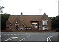
Harraton and District Community Association
On Bonemill Lane.
Image: © JThomas
Taken: 18 Aug 2018
0.07 miles
3
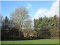
Grass and trees with houses beyond
The area is to the south of Fatfield, a district of Washington. In this vicinity there are a number of car parking areas and picnic sites all close to the River Wear and local footpaths. The river lies both behind and to the right of the camera position.
Image: © Trevor Littlewood
Taken: 8 Jan 2014
0.12 miles
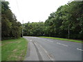
6
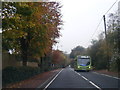
Junction of Vigo Lane and New Road
Image: © Alexander P Kapp
Taken: 23 May 2011
0.19 miles
7
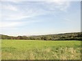
Trees with housing of Briarfield beyond
There's an open grassed area to the south of Fatfield (a district of Washington) where the name Worm Hill occurs on OS maps; the name could refer to a mound close to the camera position. The view in this image is across that grassy area towards the houses of the road named Briarfield, which can be seen through the screen of trees.
Image: © Trevor Littlewood
Taken: 8 Jan 2014
0.21 miles
8
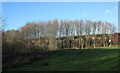
View across the woods at Chartershaugh
Looking east from the path up to The General's Wood at Harraton. Penshaw Monument can be seen on the horizon to the left.
Image: © Robert Graham
Taken: 5 Sep 2014
0.23 miles
9
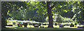
The churchyard of St George's Church in Washington, UK
The churchyard of St George's Church is the only open churchyard in Washington, Tyne and Wear.
Fatfield Parish church of St George's is based in Harraton, Washington, Tyne and Wear, covering villages of Rickleton, Harraton, Fatfield, Picktree and Mount Pleasant.
More Details: http://www.stgeorgesfatfield.co.uk/
Image: © nbhamilt
Taken: 3 Jun 2013
0.23 miles
10
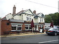
The Havelock, Fatfield, Washington
On Bonemill Lane.
Image: © JThomas
Taken: 18 Aug 2018
0.24 miles