IMAGES TAKEN NEAR TO
Wenlock, WASHINGTON, NE38 7QX
Introduction
This page details the photographs taken nearby to Wenlock, NE38 7QX by members of the Geograph project.
The Geograph project started in 2005 with the aim of publishing, organising and preserving representative images for every square kilometre of Great Britain, Ireland and the Isle of Man.

There are currently over 7.5m images from over14,400 individuals and you can help contribute to the project by visiting https://www.geograph.org.uk
Image Map
Images are licensed for reuse under creativecommons.org/licenses/by-sa/2.0
Notes
- Clicking on the map will re-center to the selected point.
- The higher the marker number, the further away the image location is from the centre of the postcode.
Image Listing (7 Images Found)
Images are licensed for reuse under creativecommons.org/licenses/by-sa/2.0
Image
Details
Distance
1
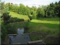
Oxclose Burn
Oxclose Burn as it emerges from an underground tunnel and flows through Princess Anne Park
Image: © Graham Scarborough
Taken: 14 Jul 2007
0.19 miles
2
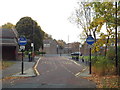
Bus-only road through Biddick, Washington
A bus-only road in the centre of Biddick, a district of Washington.
Image: © Malc McDonald
Taken: 29 Oct 2016
0.19 miles
4
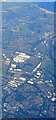
Washington from the air
The Nissan car factory dominates the scene.
Taken at around 37,000 feet by mobile phone, from a Prague bound flight from Edinburgh.
Image: © Thomas Nugent
Taken: 10 Oct 2022
0.20 miles
6
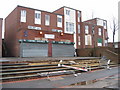
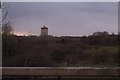
Glebe Village shop
This picture was taken just before the Glebe Village Centre was flattened for redevelopment. See Image
Image: © Dianne Snowdon
Taken: 27 Mar 2005
0.22 miles
7
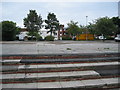
Glebe Village Centre after the shop was pulled down
Image: © Dianne Snowdon
Taken: 6 Sep 2005
0.22 miles