IMAGES TAKEN NEAR TO
Melrose, WASHINGTON, NE38 7HD
Introduction
This page details the photographs taken nearby to Melrose, NE38 7HD by members of the Geograph project.
The Geograph project started in 2005 with the aim of publishing, organising and preserving representative images for every square kilometre of Great Britain, Ireland and the Isle of Man.

There are currently over 7.5m images from over14,400 individuals and you can help contribute to the project by visiting https://www.geograph.org.uk
Image Map
Images are licensed for reuse under creativecommons.org/licenses/by-sa/2.0
Notes
- Clicking on the map will re-center to the selected point.
- The higher the marker number, the further away the image location is from the centre of the postcode.
Image Listing (8 Images Found)
Images are licensed for reuse under creativecommons.org/licenses/by-sa/2.0
Image
Details
Distance
2
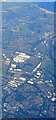
Washington from the air
The Nissan car factory dominates the scene.
Taken at around 37,000 feet by mobile phone, from a Prague bound flight from Edinburgh.
Image: © Thomas Nugent
Taken: 10 Oct 2022
0.14 miles
3
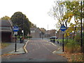
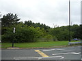
Bus-only road through Biddick, Washington
A bus-only road in the centre of Biddick, a district of Washington.
Image: © Malc McDonald
Taken: 29 Oct 2016
0.17 miles
4
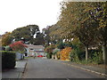
Whitby Drive, Washington
Autumn colours on Whitby Drive, in Washington.
Image: © Malc McDonald
Taken: 29 Oct 2016
0.23 miles
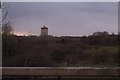
5
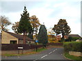
Glastonbury, Washington
This residential cul-de-sac in Washington is named Glastonbury.
Image: © Malc McDonald
Taken: 29 Oct 2016
0.24 miles
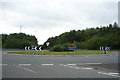
6
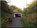
Pedestrian path and underpass, Washington
Washington was designed around car travel. Pedestrian paths use underpasses to cross major roads. As this image shows, the paths can be quite secluded which may deter people from using them.
Image: © Malc McDonald
Taken: 29 Oct 2016
0.24 miles