IMAGES TAKEN NEAR TO
Morland Avenue, WASHINGTON, NE38 7EL
Introduction
This page details the photographs taken nearby to Morland Avenue, NE38 7EL by members of the Geograph project.
The Geograph project started in 2005 with the aim of publishing, organising and preserving representative images for every square kilometre of Great Britain, Ireland and the Isle of Man.

There are currently over 7.5m images from over14,400 individuals and you can help contribute to the project by visiting https://www.geograph.org.uk
Image Map
Images are licensed for reuse under creativecommons.org/licenses/by-sa/2.0
Notes
- Clicking on the map will re-center to the selected point.
- The higher the marker number, the further away the image location is from the centre of the postcode.
Image Listing (8 Images Found)
Images are licensed for reuse under creativecommons.org/licenses/by-sa/2.0
Image
Details
Distance
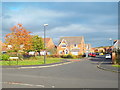
2
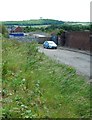
Looking over to Penshaw Monument
Image: © gordon james brown
Taken: 26 Jun 2011
0.11 miles
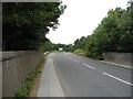
3
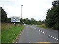
Pattinson Road Roundabout
Junction with the A195.
Image: © JThomas
Taken: 18 Aug 2018
0.15 miles
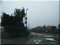
6
Pattinson Road
Looking north west from the disused railway bridge towards the A195.
Image: © JThomas
Taken: 18 Aug 2018
0.23 miles
8
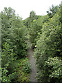
Path on disused railway, Washington
View from the bridge on Pattinson Road.
Image: © JThomas
Taken: 18 Aug 2018
0.24 miles