IMAGES TAKEN NEAR TO
Pendle Close, WASHINGTON, NE38 0PZ
Introduction
This page details the photographs taken nearby to Pendle Close, NE38 0PZ by members of the Geograph project.
The Geograph project started in 2005 with the aim of publishing, organising and preserving representative images for every square kilometre of Great Britain, Ireland and the Isle of Man.

There are currently over 7.5m images from over14,400 individuals and you can help contribute to the project by visiting https://www.geograph.org.uk
Image Map
Images are licensed for reuse under creativecommons.org/licenses/by-sa/2.0
Notes
- Clicking on the map will re-center to the selected point.
- The higher the marker number, the further away the image location is from the centre of the postcode.
Image Listing (2 Images Found)
Images are licensed for reuse under creativecommons.org/licenses/by-sa/2.0
Image
Details
Distance
2
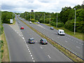
Washington Highway
The Washington Highway (A182) is the main south-north highway through Washington New Town. The slip roads lead down to a roundabout (out of sight) at the intersection with the west-east Western Highway/ Northumberland Way (A195). Seen from a bridge on the Consett and Sunderland railway path which follows a green corridor from west to east across the southern part of Washington.
Image: © Oliver Dixon
Taken: 19 Jun 2015
0.23 miles