IMAGES TAKEN NEAR TO
Hexham, WASHINGTON, NE38 0NR
Introduction
This page details the photographs taken nearby to Hexham, NE38 0NR by members of the Geograph project.
The Geograph project started in 2005 with the aim of publishing, organising and preserving representative images for every square kilometre of Great Britain, Ireland and the Isle of Man.

There are currently over 7.5m images from over14,400 individuals and you can help contribute to the project by visiting https://www.geograph.org.uk
Image Map
Images are licensed for reuse under creativecommons.org/licenses/by-sa/2.0
Notes
- Clicking on the map will re-center to the selected point.
- The higher the marker number, the further away the image location is from the centre of the postcode.
Image Listing (7 Images Found)
Images are licensed for reuse under creativecommons.org/licenses/by-sa/2.0
Image
Details
Distance
1

Christmas Day, 2007 at Berwick, Oxclose, Washington
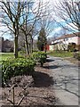
This Close was built about 1980 as part of the continuing programme of expansion of Washington New Town. Originally all the districts of the New Town were, with stunning lack of originality or imagination, identified by number; this area being District Number 3. Recently, the Council has relented and re-labelled them with user-friendly names, this being Oxclose. Naming of streets in the new housing estates must also severely tax the imagination of planners. All the streets in this estate are simply known by placenames in Northumberland, this being simply "Berwick", not Close, nor Road, nor Avenue but just that - "Berwick". No fairy lights in the trees or giant Santa Claus affixed to the outside walls; nevertheless this is indeed taken on Christmas Day.
Image: © Oliver Dixon
Taken: 25 Dec 2007
0.14 miles
2
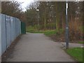
Walkway, Oxclose
There is an extensive system of walkways within Washington New Town. This one runs between Raby Road and Belsay.
Image: © Oliver Dixon
Taken: 30 Mar 2013
0.21 miles
3
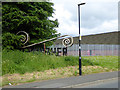
Crowther Industrial Estate
A sign announces the Crowther Industrial Estate on the western edge of Washington. Alas, a neglect of verge maintenance has left the sign overgrown and largely invisible.
Image: © Oliver Dixon
Taken: 19 Jun 2015
0.21 miles
5
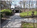
Subway under Ayton Road, Oxclose
The many walkways within Washington New Town are segregated from the main traffic arteries and feeder roads.
Image: © Oliver Dixon
Taken: 30 Mar 2013
0.22 miles
6
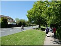
Ayton Road, Washington
One of the feeder roads of the new town, of which the residential streets are accessed. To the right, one of the many paths which provide pedestrian access to the estates.
Image: © Oliver Dixon
Taken: 31 May 2021
0.24 miles
7
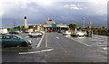
Washington Birtley Service Station
At the side of the A1(M) near Newcastle. Looking due south from MR: NZ28435518
Image: © Andy Beecroft
Taken: 12 Jun 2005
0.24 miles