IMAGES TAKEN NEAR TO
Dilston Close, WASHINGTON, NE38 0HE
Introduction
This page details the photographs taken nearby to Dilston Close, NE38 0HE by members of the Geograph project.
The Geograph project started in 2005 with the aim of publishing, organising and preserving representative images for every square kilometre of Great Britain, Ireland and the Isle of Man.

There are currently over 7.5m images from over14,400 individuals and you can help contribute to the project by visiting https://www.geograph.org.uk
Image Map
Images are licensed for reuse under creativecommons.org/licenses/by-sa/2.0
Notes
- Clicking on the map will re-center to the selected point.
- The higher the marker number, the further away the image location is from the centre of the postcode.
Image Listing (2 Images Found)
Images are licensed for reuse under creativecommons.org/licenses/by-sa/2.0
Image
Details
Distance
1
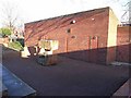
Oxclose Church, Washington
The Anglican Church in the Washington neighbourhood of Oxclose. Unlike its neighbour, St John Boste Catholic Church Image, architecturally this Church has very little to recommend it. Admittedly, this is the back wall facing a dingy cluster of neighbourhood shops. The large blocks of stone are possibly meant to be a piece of public artwork. Photographed at noon on Christmas Day, 2008.
Image: © Oliver Dixon
Taken: 25 Dec 2008
0.13 miles
2
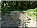
Commemorative stone in Holley Park
It is now almost impossible to decipher the inscription on this stone, but it commemorates the work of Mr Holley, one of the leading figures in the creation of Washington New Town.
Image: © Oliver Dixon
Taken: 31 May 2021
0.25 miles