IMAGES TAKEN NEAR TO
Whitbourne Close, WASHINGTON, NE37 3LL
Introduction
This page details the photographs taken nearby to Whitbourne Close, NE37 3LL by members of the Geograph project.
The Geograph project started in 2005 with the aim of publishing, organising and preserving representative images for every square kilometre of Great Britain, Ireland and the Isle of Man.

There are currently over 7.5m images from over14,400 individuals and you can help contribute to the project by visiting https://www.geograph.org.uk
Image Map (Loading...)


Getting Data...Please wait
Leaflet Map data © OpenStreetMap
Images are licensed for reuse under creativecommons.org/licenses/by-sa/2.0
Notes
- Clicking on the map will re-center to the selected point.
- The higher the marker number, the further away the image location is from the centre of the postcode.
Image Listing (5 Images Found)
Images are licensed for reuse under creativecommons.org/licenses/by-sa/2.0
Image
Details
Distance
1
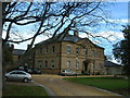
Usworth Hall
Now private and known as Manor House, this was formerly the registered office of the Washington Coal Company (from 1933).
Image: © Steve McShane
Taken: 5 Nov 2005
0.18 miles
2
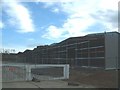
New Works
New factory construction on Stephenson Road.
Image: © Steve McShane
Taken: 5 Nov 2005
0.18 miles
3
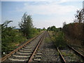
Lines near Usworth Hall
They appear to be disused by the nature and variety of the flora growing upon the tracks
Image: © Chris Heaton
Taken: 16 Aug 2006
0.20 miles
4
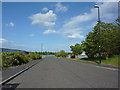
Rainhill Road, Washington
Service road in one of the many small industrial estates in Washington
Image: © Alexander P Kapp
Taken: 23 May 2011
0.21 miles
5
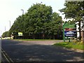
TA Centre entrance, Stephenson Road, Washington
Image: © Darrin Antrobus
Taken: 27 Aug 2013
0.23 miles