IMAGES TAKEN NEAR TO
Infiniti Drive, WASHINGTON, NE37 3HG
Introduction
This page details the photographs taken nearby to Infiniti Drive, NE37 3HG by members of the Geograph project.
The Geograph project started in 2005 with the aim of publishing, organising and preserving representative images for every square kilometre of Great Britain, Ireland and the Isle of Man.

There are currently over 7.5m images from over14,400 individuals and you can help contribute to the project by visiting https://www.geograph.org.uk
Image Map (Loading...)


Getting Data...Please wait
Leaflet Map data © OpenStreetMap
Images are licensed for reuse under creativecommons.org/licenses/by-sa/2.0
Notes
- Clicking on the map will re-center to the selected point.
- The higher the marker number, the further away the image location is from the centre of the postcode.
Image Listing (8 Images Found)
Images are licensed for reuse under creativecommons.org/licenses/by-sa/2.0
Image
Details
Distance
1
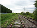
Disused railway east of Clay's Garden Centre
Image: © Alexander P Kapp
Taken: 25 May 2011
0.11 miles
2
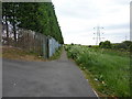
Footpath east of Clay's Garden Centre
Image: © Alexander P Kapp
Taken: 25 May 2011
0.12 miles
4
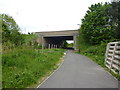
Footpath north side of Sunderland Highway
Image: © Alexander P Kapp
Taken: 25 May 2011
0.18 miles
5
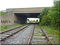
They would have to fix it before they used it again
The line as it went under the bridge had been vandalised,with the rails being loosened from the sleepers and the fish-plate removed
Image: © Alexander P Kapp
Taken: 25 May 2011
0.22 miles
6
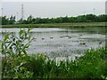
Barmston Pond
This Site of Nature Conservation Importance is particularly valuable as a refuelling stop for migratory birds and resulted from subsidence in 1970. It began life as a flooded field but the water level is now controlled by a water reservoir fed with clean water from the nearby Nissan plant.
Image: © Mick Garratt
Taken: 8 Jun 2005
0.22 miles
7
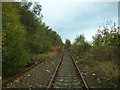
Train line through Usworth
The line, as you can see, is disused - continuing up the line would take you to the train junction east of Pelaw Metro station.
Image: © Steve McShane
Taken: 5 Nov 2005
0.22 miles
8
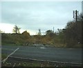
Usworth Railway Station
Well, once upon a time there used to be anyway! The line doesn't even cross the road any more (The Washington Road towards the Nissan factory and Sunderland)! This is looking south to where the station used to be. The line continues down to Penshaw Junction (where Pensaw Park tennis courts and bowling green are) - the northern-bound trains would split between those north to Newcastle and those North-East to Sunderland. The North-Easterly direction is now a good walk which ends up at the relatively new metro station South Hylton, the furthest outpost on the Tyne & Wear Metro system.
More information on the station, with photographs before and after closure in 1963, can be found at http://www.disused-stations.org.uk/u/usworth/index.shtml , as well as a history of this line.
Image: © Steve McShane
Taken: 5 Nov 2005
0.22 miles