IMAGES TAKEN NEAR TO
Sulgrave Road, WASHINGTON, NE37 3BY
Introduction
This page details the photographs taken nearby to Sulgrave Road, NE37 3BY by members of the Geograph project.
The Geograph project started in 2005 with the aim of publishing, organising and preserving representative images for every square kilometre of Great Britain, Ireland and the Isle of Man.

There are currently over 7.5m images from over14,400 individuals and you can help contribute to the project by visiting https://www.geograph.org.uk
Image Map
Images are licensed for reuse under creativecommons.org/licenses/by-sa/2.0
Notes
- Clicking on the map will re-center to the selected point.
- The higher the marker number, the further away the image location is from the centre of the postcode.
Image Listing (7 Images Found)
Images are licensed for reuse under creativecommons.org/licenses/by-sa/2.0
Image
Details
Distance
1
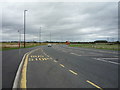
Bus stop on the A1290
New section of road near Elm Tree Farm.
Looking north.
Image: © JThomas
Taken: 18 Aug 2018
0.17 miles
2
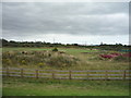
Usworth railway station (site), Tyne & Wear
Opened in 1864 by the North Eastern Railway on the line from Washington to Pelaw and Newcastle, this station closed in 1963.
View south towards Washington and Darlington. The track was lifted in 2012.
For more information, see http://www.disused-stations.org.uk/u/usworth/index.shtml
Image: © Nigel Thompson
Taken: 29 May 2021
0.19 miles
3
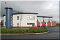
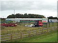
Washington fire station
Washington fire station, Glover Road, Washington, Tyne & Wear, built to replace the old fire station shown in Image and Image
Image: © Kevin Hale
Taken: 26 Nov 2006
0.20 miles
5
Elm Tree Farm, Washington
Garden nursery and tea room.
Image: © JThomas
Taken: 18 Aug 2018
0.23 miles
6
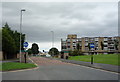
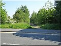
Marlborough Road, Sulgrave, Washington
Buses and cyclists only - looking east.
Image: © JThomas
Taken: 18 Aug 2018
0.25 miles