IMAGES TAKEN NEAR TO
Donvale Road, WASHINGTON, NE37 1DF
Introduction
This page details the photographs taken nearby to Donvale Road, NE37 1DF by members of the Geograph project.
The Geograph project started in 2005 with the aim of publishing, organising and preserving representative images for every square kilometre of Great Britain, Ireland and the Isle of Man.

There are currently over 7.5m images from over14,400 individuals and you can help contribute to the project by visiting https://www.geograph.org.uk
Image Map (Loading...)


Getting Data...Please wait
Leaflet Map data © OpenStreetMap
Images are licensed for reuse under creativecommons.org/licenses/by-sa/2.0
Notes
- Clicking on the map will re-center to the selected point.
- The higher the marker number, the further away the image location is from the centre of the postcode.
Image Listing (10 Images Found)
Images are licensed for reuse under creativecommons.org/licenses/by-sa/2.0
Image
Details
Distance
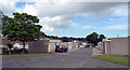
1
Parsons Road
The view up the Washington Road.
Image: © Gordon Griffiths
Taken: 5 Dec 2021
0.07 miles
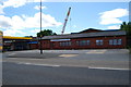
4
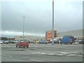
Armstrong Retail Park
A hardware supermarket in Armstrong Retail Park.
Image: © Steve McShane
Taken: 5 Nov 2005
0.17 miles
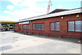
9
Nicholsons Garage , Blue House Lane
Image: © gordon james brown
Taken: 26 Jun 2011
0.21 miles