IMAGES TAKEN NEAR TO
St. Johns Terrace, EAST BOLDON, NE36 0LN
Introduction
This page details the photographs taken nearby to St. Johns Terrace, NE36 0LN by members of the Geograph project.
The Geograph project started in 2005 with the aim of publishing, organising and preserving representative images for every square kilometre of Great Britain, Ireland and the Isle of Man.

There are currently over 7.5m images from over14,400 individuals and you can help contribute to the project by visiting https://www.geograph.org.uk
Image Map
Images are licensed for reuse under creativecommons.org/licenses/by-sa/2.0
Notes
- Clicking on the map will re-center to the selected point.
- The higher the marker number, the further away the image location is from the centre of the postcode.
Image Listing (37 Images Found)
Images are licensed for reuse under creativecommons.org/licenses/by-sa/2.0
Image
Details
Distance
1
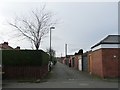
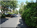
Back lane, East Boldon
Running south-west from St John's terrace, between the back gardens of Station Road and St George's Terrace.
Image: © Christine Johnstone
Taken: 25 Feb 2017
0.05 miles
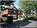
2
South side, St Mary's Terrace, East Boldon
There are semi-detached houses on the north side of this road.
Image: © Christine Johnstone
Taken: 25 Feb 2017
0.05 miles
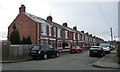
3
Houses on Glencourse
Viewed from Station Road.
Image: © DS Pugh
Taken: 2 Jul 2022
0.07 miles
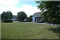
4
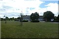
Green space in East Boldon
Looking across a green space between Station Road and Glencourse.
Image: © DS Pugh
Taken: 2 Jul 2022
0.08 miles
5
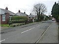
Eastern end, Nateley Avenue, East Boldon
This street was built up by 1938.
Image: © Christine Johnstone
Taken: 25 Feb 2017
0.09 miles
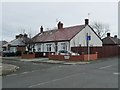
6
Bungalows and houses on Nateley Avenue
Looking westwards towards Sunderland Road. This housing was built before 1938.
Image: © Christine Johnstone
Taken: 25 Feb 2017
0.09 miles
7

East Boldon metro station on Great North Run day 2015
The platform is packed as each train arrives.
Image: © Jeremy Bolwell
Taken: 13 Sep 2015
0.11 miles
8
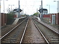
East Boldon Metro station, Tyne & Wear
Opened in 1839 as "Boldon Flatts" by the Brandling Junction Railway, later to become part of the North Eastern Railway, on the line from Newcastle to Sunderland. The name was changed to "Boldon", then "Cleadon Lane" before settling on "East Boldon" in 1898. The station was rebuilt and transferred to Metro operation in 2002.
View south east from the level crossing towards Seaburn and Sunderland.
Image: © Nigel Thompson
Taken: 10 Apr 2009
0.11 miles
9
Natley Avenue, East Boldon
Looking north east.
Image: © JThomas
Taken: 7 Jul 2018
0.11 miles