IMAGES TAKEN NEAR TO
Hardie Drive, EAST BOLDON, NE36 0JL
Introduction
This page details the photographs taken nearby to Hardie Drive, NE36 0JL by members of the Geograph project.
The Geograph project started in 2005 with the aim of publishing, organising and preserving representative images for every square kilometre of Great Britain, Ireland and the Isle of Man.

There are currently over 7.5m images from over14,400 individuals and you can help contribute to the project by visiting https://www.geograph.org.uk
Image Map
Images are licensed for reuse under creativecommons.org/licenses/by-sa/2.0
Notes
- Clicking on the map will re-center to the selected point.
- The higher the marker number, the further away the image location is from the centre of the postcode.
Image Listing (6 Images Found)
Images are licensed for reuse under creativecommons.org/licenses/by-sa/2.0
Image
Details
Distance
1
Abandoned Garage, Addison Road
Passers-by can see a helpful notice stating that this business has moved.
Image: © MSX
Taken: 4 Dec 2005
0.09 miles
2
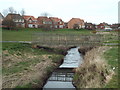
Bridge over the River Don, Boldon
A footbridge over the River Don, as it flows through a housing estate in Boldon, South Tyneside.
The Don is a tributary of the River Tyne, which it joins at Jarrow.
Image: © Malc McDonald
Taken: 4 Apr 2015
0.20 miles
3
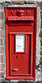
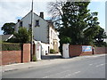
Victorian postbox on Dipe Lane, West Boldon
Postbox No. NE36 194.
See Image] for context.
Image: © JThomas
Taken: 7 Jul 2018
0.21 miles
4
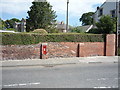
Brick wall on Dipe Lane, West Boldon
Showing position of Postbox No. NE36 194.
See Image] for postbox.
Image: © JThomas
Taken: 7 Jul 2018
0.22 miles