IMAGES TAKEN NEAR TO
Newcastle Road, EAST BOLDON, NE36 0BQ
Introduction
This page details the photographs taken nearby to Newcastle Road, NE36 0BQ by members of the Geograph project.
The Geograph project started in 2005 with the aim of publishing, organising and preserving representative images for every square kilometre of Great Britain, Ireland and the Isle of Man.

There are currently over 7.5m images from over14,400 individuals and you can help contribute to the project by visiting https://www.geograph.org.uk
Image Map
Images are licensed for reuse under creativecommons.org/licenses/by-sa/2.0
Notes
- Clicking on the map will re-center to the selected point.
- The higher the marker number, the further away the image location is from the centre of the postcode.
Image Listing (9 Images Found)
Images are licensed for reuse under creativecommons.org/licenses/by-sa/2.0
Image
Details
Distance
1
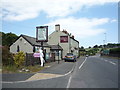
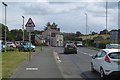
The Travelling Man public house, Mount Pleasant
On Newcastle Road (A184)
Image: © JThomas
Taken: 7 Jul 2018
0.01 miles
2
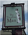
Sign for the Travelling Man public house, Mount Pleasant
Image: © JThomas
Taken: 7 Jul 2018
0.02 miles
3
Newcastle Road, West Boldon
Eastward view from near the site of Boldon Station (now a very tough to cross roundabout on the junction with Abingdon Road). The pub is The Travelling Man and there is a BMW showroom on the left.
Image: © Richard Webb
Taken: 9 Aug 2016
0.03 miles
4
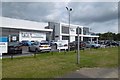
Car showroom, West Boldon
On the junction of Abingdon Road and Newcastle Road.
Image: © Richard Webb
Taken: 9 Aug 2016
0.06 miles
5
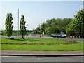
Boldon railway station (site), Tyne & Wear
Opened in 1844 by the Pontop and South Shields Railway on the line from Darlington to Gateshead via Washington. In 1849, the line was extended to Newcastle, and so Boldon was briefly on the East Coast Main Line from London to Newcastle. However, in 1850, a shorter route from Washington to Newcastle via Usworth opened. A few local services lingered on, but Boldon closed to passengers in 1853. It remained open for goods until 1967.
View south towards Washington and Darlington, from just north of the level crossing. The station was on the far side of where the roundabout now is. It had two parallel platforms, and the station building was just behind where the two trees now are. It's hard to believe now, but in 1849 this camera position would have been on the track of the East Coast Main Line!
For more information, see http://www.disused-stations.org.uk/b/boldon/index.shtml
Image: © Nigel Thompson
Taken: 29 May 2021
0.11 miles
6
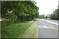
Abingdon Way
The B1298 passes the Boldon Business Park (left) - home of this striking building Image
This is the site of the Pontop and South Shields Railway which became a mineral line serving the Boldon Colliery. It closed in 1967.
Image: © Richard Webb
Taken: 9 Aug 2016
0.13 miles
7
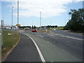
Newcastle Road (A184)
Looking east towards the roundabout at Mount Pleasant.
Image: © JThomas
Taken: 7 Jul 2018
0.14 miles