IMAGES TAKEN NEAR TO
Tile Shed Crossing, EAST BOLDON, NE36 0BN
Introduction
This page details the photographs taken nearby to Tile Shed Crossing, NE36 0BN by members of the Geograph project.
The Geograph project started in 2005 with the aim of publishing, organising and preserving representative images for every square kilometre of Great Britain, Ireland and the Isle of Man.

There are currently over 7.5m images from over14,400 individuals and you can help contribute to the project by visiting https://www.geograph.org.uk
Image Map
Images are licensed for reuse under creativecommons.org/licenses/by-sa/2.0
Notes
- Clicking on the map will re-center to the selected point.
- The higher the marker number, the further away the image location is from the centre of the postcode.
Image Listing (15 Images Found)
Images are licensed for reuse under creativecommons.org/licenses/by-sa/2.0
Image
Details
Distance
1
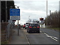
Level crossing near East Boldon
A railway level crossing near East Boldon. In this image the red lights are flashing and the barriers have been lowered, stopping road traffic to allow a train to pass through. This crossing is on the railway line between Newcastle and Sunderland, and is used by Tyne & Wear Metro trains as well as passenger and freight trains on the national rail network.
Image: © Malc McDonald
Taken: 4 Apr 2015
0.02 miles
2
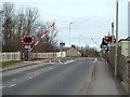
Level crossing near East Boldon
An automatic half-barrier level crossing on Tileshed Lane, near East Boldon.
In this image the red lights are flashing and the barriers are lowering, stopping road traffic to allow an approaching train to pass through. This crossing is on the railway line between Newcastle and Sunderland, and is used by Tyne & Wear Metro trains as well as passenger and freight trains on the national rail network.
Image: © Malc McDonald
Taken: 4 Apr 2015
0.02 miles
3
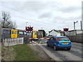
Level crossing near East Boldon
A Tyne & Wear Metro train passing through a level crossing near East Boldon. This crossing is on the railway line between Newcastle and Sunderland, and is used by passenger and freight trains on the national rail network as well as Tyne & Wear Metro trains.
Image: © Malc McDonald
Taken: 4 Apr 2015
0.02 miles
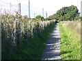
4
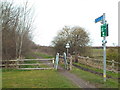
Public bridleway near East Boldon
A public bridleway leading north towards Tyne Dock. This path, which can be used by cyclists and horse riders as well as people on foot, follows the course of a dismantled railway line.
Image: © Malc McDonald
Taken: 4 Apr 2015
0.02 miles

6
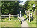
Access control off Tile Shed Lane
Access control designed to prevent motor bikes accessing this section of the West Harton Mineral Railway path.
Image: © Oliver Dixon
Taken: 30 Sep 2015
0.04 miles
7
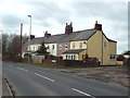
Railway Cottages, Tileshed Lane near East Boldon
Railway Cottages is a row of cottages on Tileshed lane near East Boldon. As their name suggests, they are close to a railway line.
Image: © Malc McDonald
Taken: 4 Apr 2015
0.05 miles

9

Level Crossing on Boldon Lane (B1298)
Once the old Newcastle-Sunderland line, now the Tyne and Wear Metro. The view is SE towards Sunderland.
Image: © Alan Fearon
Taken: 18 Nov 2005
0.10 miles
10
Path alongside the Metro line
A short way to the west of East Boldon station. This path is a southern continuation of the route of the old West Harton mineral railway.
Image: © Oliver Dixon
Taken: 30 Sep 2015
0.13 miles