IMAGES TAKEN NEAR TO
Rosewood Avenue, NEWCASTLE UPON TYNE, NE3 5DD
Introduction
This page details the photographs taken nearby to Rosewood Avenue, NE3 5DD by members of the Geograph project.
The Geograph project started in 2005 with the aim of publishing, organising and preserving representative images for every square kilometre of Great Britain, Ireland and the Isle of Man.

There are currently over 7.5m images from over14,400 individuals and you can help contribute to the project by visiting https://www.geograph.org.uk
Image Map
Images are licensed for reuse under creativecommons.org/licenses/by-sa/2.0
Notes
- Clicking on the map will re-center to the selected point.
- The higher the marker number, the further away the image location is from the centre of the postcode.
Image Listing (16 Images Found)
Images are licensed for reuse under creativecommons.org/licenses/by-sa/2.0
Image
Details
Distance
1
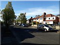
Briarwood Avenue, Gosforth, Newcastle upon Tyne
A residential street in the Garden Village part of Gosforth.
Image: © Graham Robson
Taken: 24 Apr 2020
0.04 miles
2

Bowls Club, Gosforth Garden Village, Newcastle upon Tyne
The Bowls club situated on Rosewood Avenue in the Garden Village part of Gosforth. The wooden pavilion serves as a club house and community hall.
Image: © Graham Robson
Taken: 24 Apr 2020
0.06 miles
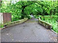
4
Bridge crossing the Ouseburn, Gosforth, Newcastle upon Tyne
A small bridge crossing the Ouseburn at the end of Woodlea Gardens in Gosforth. A road signs indicates the bridge has a 3 ton weight restriction, however small bollards in the road on the other side of the bridge make the route impassible to motorised vehicles.
Image: © Graham Robson
Taken: 16 Jun 2020
0.08 miles
5
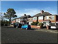
Houses, Briarwood Avenue, Gosforth, Newcastle upon Tyne
Semi-detached houses on Briarwood Avenue in the Garden Village area of Gosforth.
Image: © Graham Robson
Taken: 24 Apr 2020
0.10 miles
6

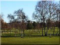
Woodlea Gardens
Leafy cul de sac at the southern end of Gosforth Golf Club.
Image: © Oliver Dixon
Taken: 4 Dec 2013
0.14 miles
7

Cheswick Drive, Gosforth, Newcastle upon Tyne
Semi detached houses on the northern side of Cheswick Drive in Gosforth.
Image: © Graham Robson
Taken: 30 May 2020
0.15 miles
8
Gosforth Golf Club
Established in 1906, Gosforth Golf Club occupies the southernmost tip of a belt of open country which extends from Gosforth Park in towards Newcastle City Centre.
Image: © Oliver Dixon
Taken: 4 Dec 2013
0.17 miles
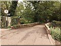
9
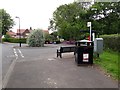
Bus turning circle, Hollywood Avenue, Gosforth, Newcastle upon Tyne
An area for service buses to turn around at the junction of Hollywood Avenue and Woodlea Gardens.
Image: © Graham Robson
Taken: 16 Jun 2020
0.17 miles
10
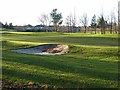
Gosforth Golf Club
The houses of Briarwood Avenue and Fernwood Avenue, South Gosforth Image can be seen in the distance.
Image: © Oliver Dixon
Taken: 4 Dec 2013
0.20 miles