IMAGES TAKEN NEAR TO
Kirkwood Place, NEWCASTLE UPON TYNE, NE3 5AU
Introduction
This page details the photographs taken nearby to Kirkwood Place, NE3 5AU by members of the Geograph project.
The Geograph project started in 2005 with the aim of publishing, organising and preserving representative images for every square kilometre of Great Britain, Ireland and the Isle of Man.

There are currently over 7.5m images from over14,400 individuals and you can help contribute to the project by visiting https://www.geograph.org.uk
Image Map
Images are licensed for reuse under creativecommons.org/licenses/by-sa/2.0
Notes
- Clicking on the map will re-center to the selected point.
- The higher the marker number, the further away the image location is from the centre of the postcode.
Image Listing (20 Images Found)
Images are licensed for reuse under creativecommons.org/licenses/by-sa/2.0
Image
Details
Distance
1
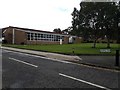
Church hall, Greenfield Road, Gosforth, Newcastle upon Tyne
The community hall attached to the neighbouring St Aidan's Parish Church in Brunton Park.
Image: © Graham Robson
Taken: 27 Jun 2020
0.07 miles
2
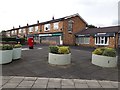
Shops, Princes Road, Gosforth, Newcastle upon Tyne
A terrace of shops with flats above in the Brunton Park area of Gosforth. Shops include a post office, convenience store, vets and estate agents.
Image: © Graham Robson
Taken: 27 Jun 2020
0.07 miles
3
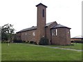
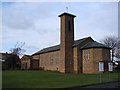
St Aidan's Parish Church, Gosforth, Newcastle upon Tyne
An Anglican parish church on Princes Road in the Brunton Park area of Gosforth.
Image: © Graham Robson
Taken: 27 Jun 2020
0.09 miles
4
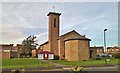
St Aidan's parish church, Brunton Park, Gosforth
Image: © Chris Morgan
Taken: 31 Oct 2016
0.09 miles
5
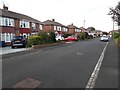
Waterbury Road, Gosforth, Newcastle upon Tyne
A residential street in Gosforth. The houses standing in either side of the street are of the same style as those in much of the immediate area.
Image: © Graham Robson
Taken: 23 May 2020
0.10 miles
7
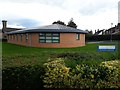
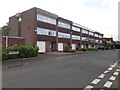
Brunton Park Health Centre, Gosforth, Newcastle upon Tyne
A modern building housing a health centre on Princes Road in the Brunton Park area of Gosforth.
Image: © Graham Robson
Taken: 27 Jun 2020
0.12 miles
8
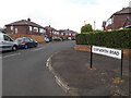
Clayworth Road, Gosforth, Newcastle upon Tyne
A residential street of semi detached houses in Gosforth.
Image: © Graham Robson
Taken: 23 May 2020
0.17 miles
9
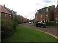
Netherwitton Way, Newcastle Great Park, Newcastle upon Tyne
A residential street in the modern housing development of Melbury Estate which makes up part of the much larger Newcastle Great Park scheme.
Image: © Graham Robson
Taken: 10 Jul 2016
0.18 miles
10
Houses on Princes Road, Gosforth, Newcastle upon Tyne
A terrace of three storey post war houses in northern Gosforth.
Image: © Graham Robson
Taken: 23 May 2020
0.18 miles