IMAGES TAKEN NEAR TO
Hedworth Lane, BOLDON COLLIERY, NE35 9JD
Introduction
This page details the photographs taken nearby to Hedworth Lane, NE35 9JD by members of the Geograph project.
The Geograph project started in 2005 with the aim of publishing, organising and preserving representative images for every square kilometre of Great Britain, Ireland and the Isle of Man.

There are currently over 7.5m images from over14,400 individuals and you can help contribute to the project by visiting https://www.geograph.org.uk
Image Map
Images are licensed for reuse under creativecommons.org/licenses/by-sa/2.0
Notes
- Clicking on the map will re-center to the selected point.
- The higher the marker number, the further away the image location is from the centre of the postcode.
Image Listing (6 Images Found)
Images are licensed for reuse under creativecommons.org/licenses/by-sa/2.0
Image
Details
Distance
1
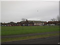
Hedworth Lane Primary School, Boldon Colliery
Image: © Les Hull
Taken: 11 Feb 2010
0.04 miles
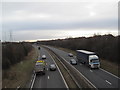
3
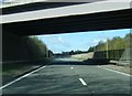
A19 passing under Hedworth Lane overbridge
Image: © Colin Pyle
Taken: 29 Apr 2018
0.14 miles
4
Cotswold Lane, Boldon Colliery
Looking north east at the junction with Cinderford Close.
Image: © JThomas
Taken: 7 Jul 2018
0.18 miles
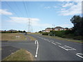
5
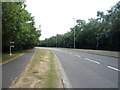
Abingdon Way, Boldon Colliery
Looking south east.
Image: © JThomas
Taken: 7 Jul 2018
0.19 miles
6
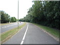
Cycle path beside Abingdon Way, Boldon Colliery
Looking south east.
Image: © JThomas
Taken: 7 Jul 2018
0.21 miles