IMAGES TAKEN NEAR TO
Brooke Avenue, BOLDON COLLIERY, NE35 9ED
Introduction
This page details the photographs taken nearby to Brooke Avenue, NE35 9ED by members of the Geograph project.
The Geograph project started in 2005 with the aim of publishing, organising and preserving representative images for every square kilometre of Great Britain, Ireland and the Isle of Man.

There are currently over 7.5m images from over14,400 individuals and you can help contribute to the project by visiting https://www.geograph.org.uk
Image Map
Images are licensed for reuse under creativecommons.org/licenses/by-sa/2.0
Notes
- Clicking on the map will re-center to the selected point.
- The higher the marker number, the further away the image location is from the centre of the postcode.
Image Listing (3 Images Found)
Images are licensed for reuse under creativecommons.org/licenses/by-sa/2.0
Image
Details
Distance
1
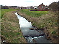
River Don, Boldon
The River Don passing through a housing estate at Boldon, in South Tyneside. The Don is a tributary of the River Tyne, which it joins at Jarrow.
Image: © Malc McDonald
Taken: 4 Apr 2015
0.06 miles
2
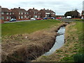
River Don, Boldon
The River Don passing through a housing estate at Boldon, in South Tyneside. The Don is a tributary of the River Tyne, which it joins at Jarrow.
Image: © Malc McDonald
Taken: 4 Apr 2015
0.13 miles
3
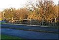
Boldon North Bridge
A rather grand name for such an undistinguished structure! The old road south to Boldon which crosses it is now only a bridleway.
Image: © Alan Fearon
Taken: 18 Nov 2005
0.20 miles