IMAGES TAKEN NEAR TO
Halterburn Close, NEWCASTLE UPON TYNE, NE3 4YT
Introduction
This page details the photographs taken nearby to Halterburn Close, NE3 4YT by members of the Geograph project.
The Geograph project started in 2005 with the aim of publishing, organising and preserving representative images for every square kilometre of Great Britain, Ireland and the Isle of Man.

There are currently over 7.5m images from over14,400 individuals and you can help contribute to the project by visiting https://www.geograph.org.uk
Image Map
Images are licensed for reuse under creativecommons.org/licenses/by-sa/2.0
Notes
- Clicking on the map will re-center to the selected point.
- The higher the marker number, the further away the image location is from the centre of the postcode.
Image Listing (17 Images Found)
Images are licensed for reuse under creativecommons.org/licenses/by-sa/2.0
Image
Details
Distance
1
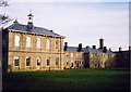
St Nicholas Hospital
Sections of this 19th Century mental hospital have been converted into elegant apartments.
Image: © Chris Bell
Taken: Unknown
0.05 miles
2
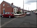
Oakfield Terrace, Gosforth, Newcastle upon Tyne
A street with bungalows on both north and south sides of the road in Gosforth. Many of them have windows in their roofs, appearing to have had loft conversions to add more living space.
Image: © Graham Robson
Taken: 20 Jun 2020
0.16 miles
3
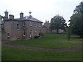
Converted hospital buildings, Gosforth, Newcastle upon Tyne
Looking across the grounds of Lanesborough Court. The building was formerly part of St Nicholas' Hospital, but has been converted into residential apartments. The building is grade II listed, https://historicengland.org.uk/listing/the-list/list-entry/1376822
Image: © Graham Robson
Taken: 18 Jun 2020
0.17 miles
4

St Nicholas Park Nature Reserve, Gosforth, Newcastle upon Tyne
A secluded spot between residential areas in Gosforth. The building (and site) belong to Northumberland Wildlife Trust.
Image: © Graham Robson
Taken: 18 Jun 2020
0.19 miles
5

Site of the former Sanderson Hospital, Gosforth, Newcastle upon Tyne
Behind the brick wall on the south side of Salter's Road is a vacant site which was once occupied by the former Sanderson Hospital. The large sign promotes a future housing development which is scheduled to be built on the site.
Image: © Graham Robson
Taken: 13 Apr 2020
0.20 miles
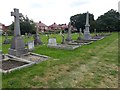
6

Ashburton Roman Catholic Cemetery, Gosforth, Newcastle upon Tyne
Lines of graves within the Ashburton Roman Catholic cemetery in Gosforth.
Image: © Graham Robson
Taken: 20 Jun 2020
0.21 miles
7

Construction site on Salters' Road, Gosforth, Newcastle upon Tyne
Construction work begins on a new housing development on the site of the former Sanderson Hospital in Gosforth. Image shows the site just 4 weeks earlier when a boundary wall (new replaced with temporary fencing) was still standing.
Image: © Graham Robson
Taken: 12 May 2020
0.21 miles
8

Bus stop on Salters Road, Gosforth
A layby and bus shelter on Salters Road.
Image: © Graham Robson
Taken: 10 Jan 2016
0.21 miles
9
Ashburton Roman Catholic Cemetery, Gosforth, Newcastle upon Tyne
Some of the graves in Ashburton Roman Catholic Cemetery in Gosforth.
Image: © Graham Robson
Taken: 20 Jun 2020
0.21 miles
10

Prince's Meadow, Gosforth, Newcastle upon Tyne
A small court of large detached houses which is part of a bigger development of houses all built in the same style.
Image: © Graham Robson
Taken: 18 Jun 2020
0.22 miles