IMAGES TAKEN NEAR TO
Bloomsbury Court, NEWCASTLE UPON TYNE, NE3 4LW
Introduction
This page details the photographs taken nearby to Bloomsbury Court, NE3 4LW by members of the Geograph project.
The Geograph project started in 2005 with the aim of publishing, organising and preserving representative images for every square kilometre of Great Britain, Ireland and the Isle of Man.

There are currently over 7.5m images from over14,400 individuals and you can help contribute to the project by visiting https://www.geograph.org.uk
Image Map
Images are licensed for reuse under creativecommons.org/licenses/by-sa/2.0
Notes
- Clicking on the map will re-center to the selected point.
- The higher the marker number, the further away the image location is from the centre of the postcode.
Image Listing (29 Images Found)
Images are licensed for reuse under creativecommons.org/licenses/by-sa/2.0
Image
Details
Distance
1

Entrance to the former Sanderson Hospital, Gosforth, Newcastle upon Tyne
The former main entrance to the site which was once occupied by the Sanderson Hospital and Sanderson Centre. The site is in the early stages of having a housing development built on it.
Image: © Graham Robson
Taken: 3 Jun 2020
0.07 miles
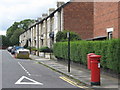
2
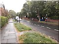
North Avenue, Gosforth, Newcastle upon Tyne
A road in a residential part of Gosforth. The land beyond the wall on the right of the photo was occupied by the Sanderson Hospital but a housing development is currently being built on the land.
Image: © Graham Robson
Taken: 3 Jun 2020
0.08 miles
3
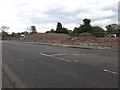
Construction site on Salters' Road, Gosforth, Newcastle upon Tyne
Construction work begins on a new housing development on the site of the former Sanderson Hospital in Gosforth. Image shows the site just 4 weeks earlier when a boundary wall (new replaced with temporary fencing) was still standing.
Image: © Graham Robson
Taken: 12 May 2020
0.09 miles
4

Site of the former Sanderson Hospital, Gosforth, Newcastle upon Tyne
Behind the brick wall on the south side of Salter's Road is a vacant site which was once occupied by the former Sanderson Hospital. The large sign promotes a future housing development which is scheduled to be built on the site.
Image: © Graham Robson
Taken: 13 Apr 2020
0.10 miles
5

Bus stop on Salters Road, Gosforth
A layby and bus shelter on Salters Road.
Image: © Graham Robson
Taken: 10 Jan 2016
0.10 miles
6
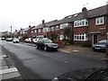
Briarfield Road, Gosforth, Newcastle upon Tyne
A residential street in Gosforth.
Image: © Graham Robson
Taken: 3 Jun 2020
0.10 miles
8
Mayfield Road, Gosforth, NE3
Shows the location of Image
Image: © Mike Quinn
Taken: 17 Aug 2010
0.11 miles
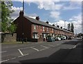
9
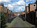
Waste collection day in Gosforth (2)
Gosforth is a district of Newcastle upon Tyne lying north of the city centre. The 'back lane' seen here is between the residential streets, Salters' Road (A191) and Broomfield Road; Linden Road crosses at the lane end.
Image: © Trevor Littlewood
Taken: 10 Jun 2014
0.11 miles
10
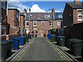
Waste collection day in Gosforth
Gosforth is a district of Newcastle upon Tyne lying north of the city centre. The 'back lane' seen here is between the residential streets, Broomfield and Mayfield Roads; Linden Road crosses at the lane end.
Image: © Trevor Littlewood
Taken: 10 Jun 2014
0.12 miles