IMAGES TAKEN NEAR TO
Westcliffe Way, SOUTH SHIELDS, NE34 9HF
Introduction
This page details the photographs taken nearby to Westcliffe Way, NE34 9HF by members of the Geograph project.
The Geograph project started in 2005 with the aim of publishing, organising and preserving representative images for every square kilometre of Great Britain, Ireland and the Isle of Man.

There are currently over 7.5m images from over14,400 individuals and you can help contribute to the project by visiting https://www.geograph.org.uk
Image Map (Loading...)


Getting Data...Please wait
Leaflet Map data © OpenStreetMap
Images are licensed for reuse under creativecommons.org/licenses/by-sa/2.0
Notes
- Clicking on the map will re-center to the selected point.
- The higher the marker number, the further away the image location is from the centre of the postcode.
Image Listing (17 Images Found)
Images are licensed for reuse under creativecommons.org/licenses/by-sa/2.0
Image
Details
Distance
1
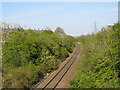
Railway line near Brockley Whins
A single-track railway close to Brockley Whins. This line is used only by freight trains going to and from Tyne Dock.
Image: © Malc McDonald
Taken: 19 Apr 2019
0.14 miles
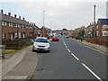
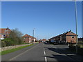
3
Brisbane Avenue, looking towards Brockley Whins Metro station
Image: © Nigel Thompson
Taken: 18 Jan 2017
0.15 miles
4
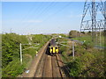
Train approaching Brockley Whins
A diesel multiple unit approaching Brockley Whins station. This line is shared by national rail operators and the Tyne & Wear Metro. The line is electrified, but only for the Metro. All other trains on this line are diesel-powered.
Image: © Malc McDonald
Taken: 19 Apr 2019
0.17 miles


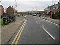
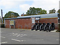
7
Brockley Whins Metro Station
On the Sunderland branch of the Tyne and Wear Metro.
Image: © Oliver Dixon
Taken: 30 Sep 2015
0.21 miles
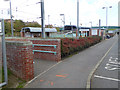
9
Brockley Whins Metro Station
Cycle racks outside the station. The notice board to the left describes the Linnet Way, a walk through the Great North Forest which starts from here and goes through to the coast at Marsden.
Image: © Oliver Dixon
Taken: 30 Sep 2015
0.21 miles
10

Great North Run
Slowing to a walk for tail enders!
Image: © Chris Morgan
Taken: 13 Sep 2015
0.21 miles