IMAGES TAKEN NEAR TO
Winskell Road, SOUTH SHIELDS, NE34 9EH
Introduction
This page details the photographs taken nearby to Winskell Road, NE34 9EH by members of the Geograph project.
The Geograph project started in 2005 with the aim of publishing, organising and preserving representative images for every square kilometre of Great Britain, Ireland and the Isle of Man.

There are currently over 7.5m images from over14,400 individuals and you can help contribute to the project by visiting https://www.geograph.org.uk
Image Map
Images are licensed for reuse under creativecommons.org/licenses/by-sa/2.0
Notes
- Clicking on the map will re-center to the selected point.
- The higher the marker number, the further away the image location is from the centre of the postcode.
Image Listing (6 Images Found)
Images are licensed for reuse under creativecommons.org/licenses/by-sa/2.0
Image
Details
Distance
1
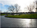
Roundabout at Simonside
Busy roundabout at the junction of Newcastle Road and John Reid Road.
Image: © Chris Tweedy
Taken: 17 Jan 2006
0.15 miles
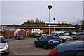
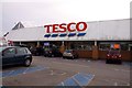
2
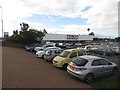
Tesco, Jarrow
A Tesco supermarket off Newcastle Road in Jarrow.
Image: © Graham Robson
Taken: 7 Oct 2017
0.22 miles
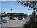
4
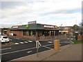
Adjacent fast food restaurants, Jarrow
In the foreground is a McDonald's drive through restaurant, behind it is a more recently opened Burger King restaurant.
Image: © Graham Robson
Taken: 7 Oct 2017
0.23 miles