IMAGES TAKEN NEAR TO
King George Road, SOUTH SHIELDS, NE34 8AQ
Introduction
This page details the photographs taken nearby to King George Road, NE34 8AQ by members of the Geograph project.
The Geograph project started in 2005 with the aim of publishing, organising and preserving representative images for every square kilometre of Great Britain, Ireland and the Isle of Man.

There are currently over 7.5m images from over14,400 individuals and you can help contribute to the project by visiting https://www.geograph.org.uk
Image Map (Loading...)


Getting Data...Please wait
Leaflet Map data © OpenStreetMap
Images are licensed for reuse under creativecommons.org/licenses/by-sa/2.0
Notes
- Clicking on the map will re-center to the selected point.
- The higher the marker number, the further away the image location is from the centre of the postcode.
Image Listing (16 Images Found)
Images are licensed for reuse under creativecommons.org/licenses/by-sa/2.0
Image
Details
Distance
1
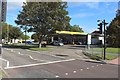
Filling station, King George Road, South Shields
A Jet branded filling station beside King George Road on the southern edge of South Shields.
Image: © Graham Robson
Taken: 23 Sep 2018
0.02 miles
2
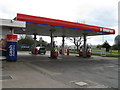
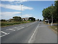
Murco Filling Station, King George Road
Image: © Alex McGregor
Taken: 20 Apr 2010
0.02 miles
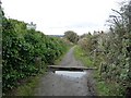
3
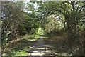
Bridleway on the edge of Cleadon Park
A public bridleway which follows the boundary between the Cleadon Park housing estate (on the left) and as yet undeveloped arable fields (on the right).
Image: © Graham Robson
Taken: 23 Sep 2018
0.02 miles
4
Indian restaurant, King George Road, South Shields
Namaste is an Indian themed restaurant beside King George Road on the southern edge of South Shields.
Image: © Graham Robson
Taken: 23 Sep 2018
0.03 miles
5
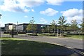
South Shields School
A large and modern school building off Nevinson Avenue in South Shields. The school provides education to children between the ages of 11 and 16.
Image: © Graham Robson
Taken: 23 Sep 2018
0.10 miles
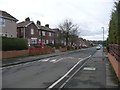
6

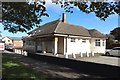
The 'White Ensign' at Harton.
On the main road South from Harton to Sunderland.
Image: © Roger Cornfoot
Taken: 16 Dec 2006
0.13 miles
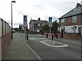
7
Speed bumps on The Ridgeway
A suburban road linking the A1018 [King George Road] with Sunderland Road.
Image: © Christine Johnstone
Taken: 25 Feb 2017
0.15 miles
8
End of Home Zone, Sycamore Avenue
Near the junction with The Ridgeway.
Image: © Christine Johnstone
Taken: 25 Feb 2017
0.17 miles
9
Motorcycle barrier at the bridleway entrance
Heading south off Sunderland Road.
Image: © Christine Johnstone
Taken: 25 Feb 2017
0.22 miles
10
Sunderland Road, Cleadon, South Shields
Looking north outside the New Ship Inn.
Image: © JThomas
Taken: 7 Jul 2018
0.23 miles