IMAGES TAKEN NEAR TO
Cheviot Road, SOUTH SHIELDS, NE34 7ST
Introduction
This page details the photographs taken nearby to Cheviot Road, NE34 7ST by members of the Geograph project.
The Geograph project started in 2005 with the aim of publishing, organising and preserving representative images for every square kilometre of Great Britain, Ireland and the Isle of Man.

There are currently over 7.5m images from over14,400 individuals and you can help contribute to the project by visiting https://www.geograph.org.uk
Image Map
Images are licensed for reuse under creativecommons.org/licenses/by-sa/2.0
Notes
- Clicking on the map will re-center to the selected point.
- The higher the marker number, the further away the image location is from the centre of the postcode.
Image Listing (5 Images Found)
Images are licensed for reuse under creativecommons.org/licenses/by-sa/2.0
Image
Details
Distance
1
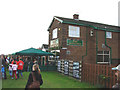
The Bamburgh Public House, seen from Coast Road, the A183, South Shields.
Image: © Bill Henderson
Taken: 1 Oct 2006
0.21 miles
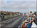
2
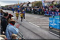
Nearly at the finish
The final part of the route of the Great North Run follows Coast Road for a little over a mile.
Image: © Bill Boaden
Taken: 18 Sep 2011
0.22 miles
3
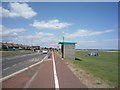
Bus stop and shelter beside National Cycle Route 1
Looking north west beside Coast Road (A183).
Image: © JThomas
Taken: 7 Jul 2018
0.23 miles
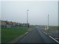
4
The A 183, Coast Road, South Shields.
This is Coast Road during the morning of the Great North Run Race day, looking north west towards the finishing line. One hour after the photograph was taken, both sides of Coast Road were packed with spectators.
Image: © Bill Henderson
Taken: 1 Oct 2006
0.24 miles