IMAGES TAKEN NEAR TO
Bishop Ramsey Court, SOUTH SHIELDS, NE34 7SQ
Introduction
This page details the photographs taken nearby to Bishop Ramsey Court, NE34 7SQ by members of the Geograph project.
The Geograph project started in 2005 with the aim of publishing, organising and preserving representative images for every square kilometre of Great Britain, Ireland and the Isle of Man.

There are currently over 7.5m images from over14,400 individuals and you can help contribute to the project by visiting https://www.geograph.org.uk
Image Map (Loading...)


Getting Data...Please wait
Leaflet Map data © OpenStreetMap
Images are licensed for reuse under creativecommons.org/licenses/by-sa/2.0
Notes
- Clicking on the map will re-center to the selected point.
- The higher the marker number, the further away the image location is from the centre of the postcode.
Image Listing (23 Images Found)
Images are licensed for reuse under creativecommons.org/licenses/by-sa/2.0
Image
Details
Distance
1
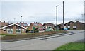
Bishop Ramsay Court sheltered accommodation
On the east side of Centenary Avenue.
Image: © Christine Johnstone
Taken: 25 Feb 2017
0.01 miles
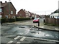
2
![Witton Avenue [south side]](https://s1.geograph.org.uk/geophotos/05/30/05/5300597_3aceca09_120x120.jpg)
Witton Avenue [south side]
Linking Centenary Avenue and Hylton Avenue.
Image: © Christine Johnstone
Taken: 25 Feb 2017
0.02 miles
3
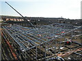
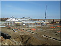
Harton Primary School, South Shields
Erection of structural steel framework to the new Primary School at Harton on the 10th March 2010. The existing Harton Primary school (Christie Building) can be seen in the background of the image.
Image: © Philip Soakell
Taken: 10 Mar 2010
0.06 miles
4
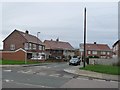
Barbour Avenue
On the west side of Centenary Avenue.
Image: © Christine Johnstone
Taken: 25 Feb 2017
0.06 miles
5
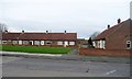
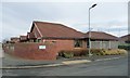
Bungalows on the west side of Centenary Avenue
Built round three sides of a rectangle of grass.
Image: © Christine Johnstone
Taken: 25 Feb 2017
0.06 miles
6
Harton Primary School, South Shields
Erection of structural steel frame for new Primary School at Harton on 10th March 2010.
Image: © Philip Soakell
Taken: 10 Mar 2010
0.07 miles
7
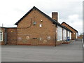
Harton Primary School, South Shields
Upper School (Stephenson Building) in April 2010.
The new primary school was built on the land between the Stephenson Building and Christie Building. These buildings were demolished on the completion of the new school.
Image: © Philip Soakell
Taken: 8 Apr 2010
0.08 miles
8
Housing on Riverslea, off Centenary Avenue
Built by Three Rivers Housing - a housing association from Peterlee, which is now part of Four Housing, which itself has become part of the Bernicia Group.
Image: © Christine Johnstone
Taken: 25 Feb 2017
0.09 miles
9
Houses with solar panels, on School Approach
On the west side of Centenary Avenue.
Image: © Christine Johnstone
Taken: 25 Feb 2017
0.10 miles
10
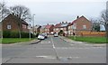
Barbour Avenue
Looking south from the junction with Fenton Avenue.
Image: © Christine Johnstone
Taken: 25 Feb 2017
0.11 miles