IMAGES TAKEN NEAR TO
Lumley Avenue, SOUTH SHIELDS, NE34 7DL
Introduction
This page details the photographs taken nearby to Lumley Avenue, NE34 7DL by members of the Geograph project.
The Geograph project started in 2005 with the aim of publishing, organising and preserving representative images for every square kilometre of Great Britain, Ireland and the Isle of Man.

There are currently over 7.5m images from over14,400 individuals and you can help contribute to the project by visiting https://www.geograph.org.uk
Image Map (6 Images)


Getting Data...Please wait
Leaflet Map data © OpenStreetMap
Images are licensed for reuse under creativecommons.org/licenses/by-sa/2.0
Notes
- Clicking on the map will re-center to the selected point.
- The higher the marker number, the further away the image location is from the centre of the postcode.
Image Listing (6 Images Found)
Images are licensed for reuse under creativecommons.org/licenses/by-sa/2.0
Image
Details
Distance
1
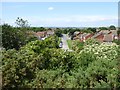
Valley Road, Marsden
Seen from the elevated land of the Marsden Old Quarry Local Nature Reserve.
Image: © Oliver Dixon
Taken: 19 Jun 2017
0.20 miles
2
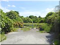
Entrance to Marsden Old Quarry Local Nature Reserve
From Valley Road.
Image: © Oliver Dixon
Taken: 19 Jun 2017
0.23 miles
3
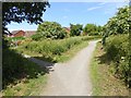
Path junction at the entrance to Marsden Old Quarry Local Nature Reserve
A public footpath runs along the north side of the reserve.
Image: © Oliver Dixon
Taken: 19 Jun 2017
0.23 miles
4
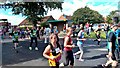
Elvis Presley, in South Shields
Entertainment for Great North Run participants
Image: © Chris Morgan
Taken: 13 Sep 2015
0.24 miles
5
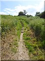
Steps in Marsden Old Quarry Local Nature Reserve
The reserve comprises some very broken ground.
Image: © Oliver Dixon
Taken: 19 Jun 2017
0.24 miles
6
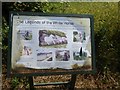
Legends of the White Horse
Board at the entrance to Marsden Old Quarry Local Nature Reserve expounding six possible accounts (some more plausible than others!) to explain the presence of a large white horse painted on a rock face.
Image: © Oliver Dixon
Taken: 19 Jun 2017
0.24 miles