IMAGES TAKEN NEAR TO
Quarry Lane, SOUTH SHIELDS, NE34 7AR
Introduction
This page details the photographs taken nearby to Quarry Lane, NE34 7AR by members of the Geograph project.
The Geograph project started in 2005 with the aim of publishing, organising and preserving representative images for every square kilometre of Great Britain, Ireland and the Isle of Man.

There are currently over 7.5m images from over14,400 individuals and you can help contribute to the project by visiting https://www.geograph.org.uk
Image Map
Images are licensed for reuse under creativecommons.org/licenses/by-sa/2.0
Notes
- Clicking on the map will re-center to the selected point.
- The higher the marker number, the further away the image location is from the centre of the postcode.
Image Listing (101 Images Found)
Images are licensed for reuse under creativecommons.org/licenses/by-sa/2.0
Image
Details
Distance
1
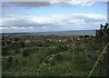
Looking north from Marsden Quarry
This is the view up the coast from the southern side of the Old Quarry at Marsden. Excellent views can be had from here on a clear day. In this shot, South Shields and St Mary's Lighthouse at Whitley Bay can be made out.
Image: © Robert Graham
Taken: 30 Aug 2004
0.09 miles
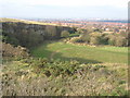
2
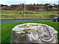
Marsden Old Quarry from Lizard Lane
Marsden Old Quarry is managed as a Local Nature Reserve as a unique site for wildlife. It is a site of geological importance being on a long thin band of Magnesian Limestone that stretches from South Shields to Nottingham. Only a few miles wide, this strip was laid down 260 million years ago, in the Permian Period.
The lizard is one of three large limestone sculptures - an abstract owl, a lizard and an armchair. They are the work of Marsden artist, ‘Ant’ Bryant. The public art project was backed by donation of the rock by neighbouring Marsden Quarry operator, Owen Pugh Aggregates, for the Limestone Landscapes Partnership.
The nearby Souter Lighthouse occupies a location on Marsden's Lizard Point although named after the more southerly Souter Point to avoid confusion with the lighthouse on Lizard Point in Cornwall. The latter is said to take its name from the Cornish words, Lis for 'place' and Ard for 'high'. There are several Lizard place names in this part of South-Tyneside including the Cleadon Lizards, which along with North Field, was part of the medieval common field system on the Cleadon Hills. It possibly also had a similar origin in the appearance of the hills from sea when such things were important for navigation. However, the Common or Viviparous Lizard (Zootoca vivipara) is found in this region of magnesian limestone, including on nearby Lizard's Farm so perhaps it's derivation is not so complicated
https://web.archive.org/web/20200205125902/http://www.nhsn.ncl.ac.uk/interests/reptiles-amphibians/common-lizard/
Image: © Andrew Curtis
Taken: 30 Jan 2020
0.09 miles
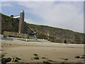
6

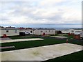
Marsden Grotto, South Shields
Marsden Grotto is a pub and cafe at the foot of the cliffs, accessed by bridge and lift as shown in the photograph
Image: © Oliver Dixon
Taken: 19 Feb 2006
0.14 miles
7
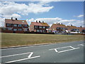
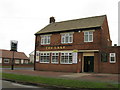
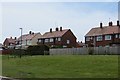
Houses on Grotto Road, Marsden
View from National Cycle Route 1.
Image: © JThomas
Taken: 7 Jul 2018
0.14 miles
8
Disused quarry Marsden
Now part of Marsden Old Quarry Nature Reserve, South Tyneside.
Image: © Peter Robinson
Taken: 15 Nov 2009
0.15 miles
9
Marsden Bay Grotto
Interesting pub at the foot of the cliff in Marsden Bay - accessed by a lift. Several bars are within caves.
Image: © Angus Townley
Taken: 19 Jul 2003
0.15 miles
10
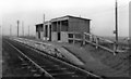
Marsden Cottage Halt, South Shields, Marsden & Whitburn Colliery Railway, 1953
View NW, towards South Shields, on the Last (Passenger) Train from Whitburn Colliery, on the day it closed (22/11/53).
Image: © Walter Dendy, deceased
Taken: 20 Nov 1953
0.15 miles