IMAGES TAKEN NEAR TO
Russell Avenue, SOUTH SHIELDS, NE34 6PW
Introduction
This page details the photographs taken nearby to Russell Avenue, NE34 6PW by members of the Geograph project.
The Geograph project started in 2005 with the aim of publishing, organising and preserving representative images for every square kilometre of Great Britain, Ireland and the Isle of Man.

There are currently over 7.5m images from over14,400 individuals and you can help contribute to the project by visiting https://www.geograph.org.uk
Image Map (Loading...)


Getting Data...Please wait
Leaflet Map data © OpenStreetMap
Images are licensed for reuse under creativecommons.org/licenses/by-sa/2.0
Notes
- Clicking on the map will re-center to the selected point.
- The higher the marker number, the further away the image location is from the centre of the postcode.
Image Listing (22 Images Found)
Images are licensed for reuse under creativecommons.org/licenses/by-sa/2.0
Image
Details
Distance
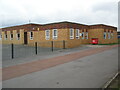
1
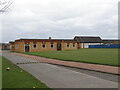
Harton Primary School, South Shields
Kitchen and Dining Hall in the foreground with the Christie Building (Low School) in the background as viewed in April 2010. Both buildings were later demolished on completion of the construction of the new primary school.
Image: © Philip Soakell
Taken: 8 Apr 2010
0.14 miles
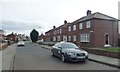
2
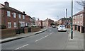
The north end of Dunlop Crescent
On the west side of Centenary Avenue.
Image: © Christine Johnstone
Taken: 25 Feb 2017
0.14 miles
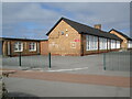
3
Harton Primary School, South Shields
Harton Primary Low School (Christie Building) in April 2010.
The new primary school was constructed behind the Christie Building.
On completion of the new primary school the Christie Building was demolished to accommodate the landscaped areas / play fields for the new school.
Image: © Philip Soakell
Taken: 8 Apr 2010
0.14 miles
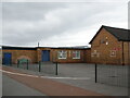
4
Harton Primary School, South Shields
Infants & Nursery.
Image: © Philip Soakell
Taken: 8 Apr 2010
0.14 miles
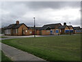
5
Harton Primary School, South Shields
Kitchen and Dining Hall in April 2010. The building was later demolished to accommodate the playing fields for the new primary school.
Image: © Philip Soakell
Taken: 8 Apr 2010
0.14 miles
6
The north end of East Avenue
Linking Centenary Avenue with Prince Edward Road.
Image: © Christine Johnstone
Taken: 25 Feb 2017
0.15 miles
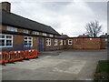
7
Harton Primary School, South Shields
Harton Primary School - (Lower School - Christie Building) in April 2010. The Christie Building was demolished after the construction of the new school which was located within the same school grounds. Part of the construction of the roof for the new school can be seen on the left of the image above the existing flat roof.
Image: © Philip Soakell
Taken: 14 Apr 2010
0.15 miles
8
Harton Primary School, South Shields
The Lower School (Christie Building) in 2010. The building was demolished upon completion of the new primary school to make way for playing fields/ landscaped areas for the new school.
Image: © Philip Soakell
Taken: 8 Apr 2010
0.15 miles
9
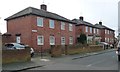
Houses on the south side of York Way
A short road connecting Dunlop Crescent and Borough Road.
Image: © Christine Johnstone
Taken: 25 Feb 2017
0.17 miles
10
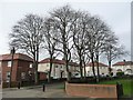
Trees on Dunlop Crescent
On the pavements of a 'subsidiary' cul-de-sac.
Image: © Christine Johnstone
Taken: 25 Feb 2017
0.17 miles