IMAGES TAKEN NEAR TO
King George Road, SOUTH SHIELDS, NE34 0EX
Introduction
This page details the photographs taken nearby to King George Road, NE34 0EX by members of the Geograph project.
The Geograph project started in 2005 with the aim of publishing, organising and preserving representative images for every square kilometre of Great Britain, Ireland and the Isle of Man.

There are currently over 7.5m images from over14,400 individuals and you can help contribute to the project by visiting https://www.geograph.org.uk
Image Map
Images are licensed for reuse under creativecommons.org/licenses/by-sa/2.0
Notes
- Clicking on the map will re-center to the selected point.
- The higher the marker number, the further away the image location is from the centre of the postcode.
Image Listing (8 Images Found)
Images are licensed for reuse under creativecommons.org/licenses/by-sa/2.0
Image
Details
Distance
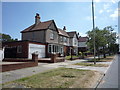
1
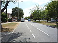
Looking south on King George Road, South Shields
Image: © JThomas
Taken: 7 Jul 2018
0.07 miles
4
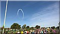
Red Arrows star burst
Above Great North Run participants
Image: © Chris Morgan
Taken: 13 Sep 2015
0.09 miles
5
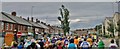
Heavy congestion on the way to the coast!
On the Great North Run, 2013.
Image: © Chris Morgan
Taken: 15 Sep 2013
0.17 miles
7
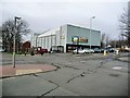
Farmfoods, on Sunderland Road
A frozen food shop in what looks like a converted cinema.
Image: © Christine Johnstone
Taken: 25 Feb 2017
0.20 miles
8
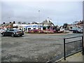
Roundabout with royal connections at Harton Nook
At the junction of Prince Edward Road [A1300] and Sunderland Road.
Image: © Christine Johnstone
Taken: 25 Feb 2017
0.24 miles