IMAGES TAKEN NEAR TO
Mary Agnes Street, NEWCASTLE UPON TYNE, NE3 3XB
Introduction
This page details the photographs taken nearby to Mary Agnes Street, NE3 3XB by members of the Geograph project.
The Geograph project started in 2005 with the aim of publishing, organising and preserving representative images for every square kilometre of Great Britain, Ireland and the Isle of Man.

There are currently over 7.5m images from over14,400 individuals and you can help contribute to the project by visiting https://www.geograph.org.uk
Image Map
Images are licensed for reuse under creativecommons.org/licenses/by-sa/2.0
Notes
- Clicking on the map will re-center to the selected point.
- The higher the marker number, the further away the image location is from the centre of the postcode.
Image Listing (19 Images Found)
Images are licensed for reuse under creativecommons.org/licenses/by-sa/2.0
Image
Details
Distance
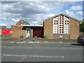
3
Methodist Church
Methodist church opposite the Public House known as the Trap.
Image: © Newbiggin Hall Scouts
Taken: 26 May 2007
0.09 miles
4

Cox Lodge Methodist Church
On Kenton Road.
Image: © Oliver Dixon
Taken: 1 Feb 2013
0.09 miles
5
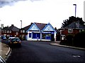
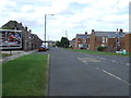
Local Shop
Corner shop bottom of Nelson Ave. Coxlodge
Image: © Newbiggin Hall Scouts
Taken: 26 May 2007
0.09 miles
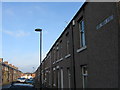
7
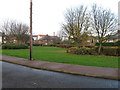
Open space, Jubilee Crescent, Coxlodge
Image: © Alex McGregor
Taken: 22 Nov 2011
0.10 miles
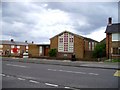
8
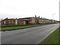
Coxlodge Methodist Church, Kenton Road, Coxlodge
Coxlodge Methodist Church sitting at the end of a terrace of houses on Kenton Road.
Image: © Graham Robson
Taken: 10 Feb 2018
0.10 miles
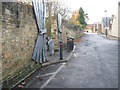
9
Nelson Ave, Coxlodge
Looking North along Nelson Ave. Coxlodge.
Image: © Newbiggin Hall Scouts
Taken: 6 Apr 2007
0.11 miles