IMAGES TAKEN NEAR TO
Regent Farm Road, NEWCASTLE UPON TYNE, NE3 3HD
Introduction
This page details the photographs taken nearby to Regent Farm Road, NE3 3HD by members of the Geograph project.
The Geograph project started in 2005 with the aim of publishing, organising and preserving representative images for every square kilometre of Great Britain, Ireland and the Isle of Man.

There are currently over 7.5m images from over14,400 individuals and you can help contribute to the project by visiting https://www.geograph.org.uk
Image Map
Images are licensed for reuse under creativecommons.org/licenses/by-sa/2.0
Notes
- Clicking on the map will re-center to the selected point.
- The higher the marker number, the further away the image location is from the centre of the postcode.
Image Listing (12 Images Found)
Images are licensed for reuse under creativecommons.org/licenses/by-sa/2.0
Image
Details
Distance
1
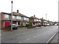
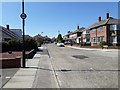
Regent Farm Road, Gosforth
Regent Farm Road, lined on either side with semi detached houses.
Image: © Graham Robson
Taken: 10 Feb 2018
0.02 miles
2
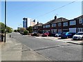
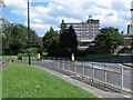
Regent Farm Road, Gosforth, Newcastle upon Tyne
A residential street in Gosforth with large, modern, multi-storey office building in the background.
Image: © Graham Robson
Taken: 6 May 2020
0.06 miles
3
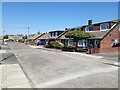
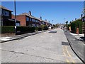
Rothbury Avenue, Gosforth, Newcastle upon Tyne
A residential street in Gosforth. Several of the bungalows have had extensive extensions built into their attics to create extra living space.
Image: © Graham Robson
Taken: 6 May 2020
0.07 miles
4
Regent Chapel, Regent Farm Road, Gosforth
The modern church building dating from the 1970s is the home of the Regent Chapel Christian Fellowship.
Image: © Graham Robson
Taken: 10 Feb 2018
0.08 miles
5
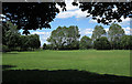
Grassed area adjacent to St. Charles RC School
The grassed area lies to the north of Regent Farm Road in Gosforth, part of Newcastle upon Tyne. The area is unfenced though there is a low wall and so it's assumed that the land is not part of the school grounds.
Image: © Trevor Littlewood
Taken: 10 Jun 2014
0.12 miles
6
Rothbury Avenue, Gosforth, Newcastle upon Tyne
A quiet street in a residential part of Gosforth.
Image: © Graham Robson
Taken: 6 May 2020
0.13 miles
7
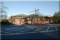
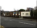
Gosforth fire station
Gosforth fire station, Jubilee Road, Gosforth, Tyne & Wear
Image: © Kevin Hale
Taken: 26 Nov 2006
0.14 miles
8
Brinkburn Avenue, Gosforth, Newcastle upon Tyne
A street with semi-detached houses on both sides in the Gosforth part of Newcastle.
Image: © Graham Robson
Taken: 6 May 2020
0.15 miles
9
Roundabout at Regent Centre
The Regent Centre is a complex of office buildings with a major transport interchange at the northern end of Gosforth, which itself is part of the city, Newcastle upon Tyne.
Image: © Trevor Littlewood
Taken: 10 Jun 2014
0.22 miles
10
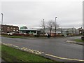
ASDA supermarket, Fawdon
A small branch of the ASDA supermarket chain located off Wansbeck Road South in Fawdon.
Image: © Graham Robson
Taken: 10 Feb 2018
0.24 miles