
IMAGES TAKEN NEAR TO
Rekendyke Lane, SOUTH SHIELDS, NE33 1SG
Introduction
This page details the photographs taken nearby to Rekendyke Lane, NE33 1SG by members of the Geograph project.
The Geograph project started in 2005 with the aim of publishing, organising and preserving representative images for every square kilometre of Great Britain, Ireland and the Isle of Man.

There are currently over 7.5m images from over14,400 individuals and you can help contribute to the project by visiting https://www.geograph.org.uk
Image Map
Images are licensed for reuse under creativecommons.org/licenses/by-sa/2.0
Notes
- Clicking on the map will re-center to the selected point.
- The higher the marker number, the further away the image location is from the centre of the postcode.
Image Listing (57 Images Found)
Images are licensed for reuse under creativecommons.org/licenses/by-sa/2.0
Image
Details
Distance
3
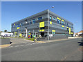
One Trinity Green, South Shields
New stste of the art building, completed 2012, to house environmental businesses. The fork lift truck in the foreground belongs to one of the occupants, JC Events and is carrying a couple of what look suspiciously like giant Rubik cubes.
Image: © Oliver Dixon
Taken: 30 Sep 2015
0.05 miles
4
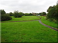
South Shields 1st BJR railway station (site), Tyne & Wear
Opened in 1839 by the Brandling Junction Railway, later part of the North Eastern Railway, as the terminus of the line from Gateshead. This short-lived station closed to passengers in 1842 when it was replaced by a more centrally located station. This location is actually in High Shields.
View north east towards the buffers. The line entered the site from bottom right and terminated in the middle distance, probably to the left of the modern path. The structure appeared to be made of timber. The site has been redeveloped more than once and had become a public park when this image was taken.
Image: © Nigel Thompson
Taken: 28 Aug 2019
0.06 miles
5
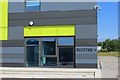
New office block
Newly built offices on land that was once a densely packed residential area of terraced houses. I did not note the name of the building, hoping to pick it up off Streetview, but the Streetview image predates the construction.
Image: © Richard Webb
Taken: 18 Jun 2013
0.07 miles
6
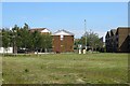
Open area
Once residential streets of terraced houses, this is now an open space which may be developed.
Image: © Richard Webb
Taken: 18 Jun 2013
0.08 miles
7
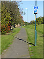
National Cycle Network route 14
National Cycle Network Route 14 pursues a zigzag course from Darlington via Hartlepool and Consett to finish at South Shields. At this point, north of Laygate in South Shields, the route closely parallels an old railway line on an embankment to the left of the path.
Image: © Oliver Dixon
Taken: 30 Sep 2015
0.09 miles
9
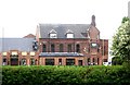
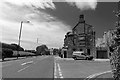
Brunswick Hotel, South Shields
137 Commercial Road.
Image: © Stanley Howe
Taken: 16 Apr 2011
0.09 miles
10
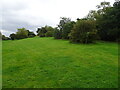
High Shields 2nd railway station (site), Tyne & Wear
Opened in 1879 by the North Eastern Railway on the line from Pelaw to South Shields (Low), this station closed in 1981 and was demolished.
View north east towards Low Shields. All trace of the railway has been removed here and the area redeveloped and landscaped.
Image: © Nigel Thompson
Taken: 28 Aug 2019
0.10 miles