IMAGES TAKEN NEAR TO
Glanton Wynd, NEWCASTLE UPON TYNE, NE3 2LQ
Introduction
This page details the photographs taken nearby to Glanton Wynd, NE3 2LQ by members of the Geograph project.
The Geograph project started in 2005 with the aim of publishing, organising and preserving representative images for every square kilometre of Great Britain, Ireland and the Isle of Man.

There are currently over 7.5m images from over14,400 individuals and you can help contribute to the project by visiting https://www.geograph.org.uk
Image Map
Images are licensed for reuse under creativecommons.org/licenses/by-sa/2.0
Notes
- Clicking on the map will re-center to the selected point.
- The higher the marker number, the further away the image location is from the centre of the postcode.
Image Listing (19 Images Found)
Images are licensed for reuse under creativecommons.org/licenses/by-sa/2.0
Image
Details
Distance
1
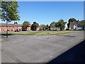
Gosforth Sports Association ground
The building and associated pitches used by Gosforth Sports Association. The association is the home of Newcastle Cricket Club and Gosforth Rugby Club.
Image: © Graham Robson
Taken: 10 Feb 2018
0.08 miles
2
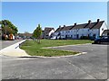
Grass square on Park Avenue, Gosforth, Newcastle upon Tyne
A square of grass providing some public open space in front of houses on Park Avenue.
Image: © Graham Robson
Taken: 6 May 2020
0.08 miles
3
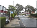
Park Avenue, Gosforth
Signed as an advisory cycle route.
Image: © Oliver Dixon
Taken: 2 Sep 2019
0.10 miles
4
Park Avenue, Gosforth, Newcastle upon Tyne
A small patch of grass on Park Avenue with a line of young trees.
Image: © Graham Robson
Taken: 6 May 2020
0.15 miles
5
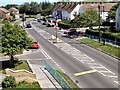
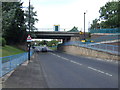
Wansbeck Road North
This was taken from the bridge of Wansbeck Road Metro station, looking north.
Image: © Lis Burke
Taken: 25 Jun 2005
0.17 miles
6
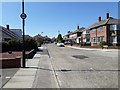
Rothbury Avenue, Gosforth, Newcastle upon Tyne
A quiet street in a residential part of Gosforth.
Image: © Graham Robson
Taken: 6 May 2020
0.18 miles
7
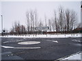
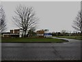
Mini-roundabout near golf course and playing fields
This photograph shows a mini-roundabout near the City of Newcastle Golf Course and playing fields which are located just to the north of the roundabout (behind the line of trees). The picture was taken just after a recent fall of snow in early January looking in a northerly direction towards the golf course.
Image: © Philip Barker
Taken: 2 Jan 2010
0.18 miles
8
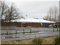
Red House Farm Football Club building
The building adjoining the pitches of Red House Farm Juniors Football Club.
Image: © Graham Robson
Taken: 10 Feb 2018
0.20 miles
10
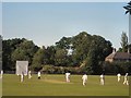
Cricket Match
These playing fields are just to the east of the A1 in a residential area.
Image: © Lis Burke
Taken: 25 Jun 2005
0.22 miles