IMAGES TAKEN NEAR TO
Sheen Court, NEWCASTLE UPON TYNE, NE3 2FQ
Introduction
This page details the photographs taken nearby to Sheen Court, NE3 2FQ by members of the Geograph project.
The Geograph project started in 2005 with the aim of publishing, organising and preserving representative images for every square kilometre of Great Britain, Ireland and the Isle of Man.

There are currently over 7.5m images from over14,400 individuals and you can help contribute to the project by visiting https://www.geograph.org.uk
Image Map
Images are licensed for reuse under creativecommons.org/licenses/by-sa/2.0
Notes
- Clicking on the map will re-center to the selected point.
- The higher the marker number, the further away the image location is from the centre of the postcode.
Image Listing (25 Images Found)
Images are licensed for reuse under creativecommons.org/licenses/by-sa/2.0
Image
Details
Distance
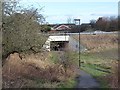
1

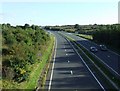
The A696 to Newcastle
Note the cycle lane which diverts riders away from the broad sweep of the slip road junction.
Image: © Thomas Nugent
Taken: 6 Oct 2008
0.13 miles
2
The A696 to Newcastle
Viewed from the flyover at Newbiggin Lane.
Image: © Thomas Nugent
Taken: 6 Oct 2008
0.15 miles
3
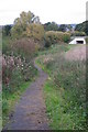
Secret path
Another part of the secret walk
Image: © Newbiggin Hall Scouts
Taken: 1 Jul 2007
0.16 miles
4
Subway
Looking from Bluebell Dene at the subway under the A696 on the edge of Newbiggin Hall.
Image: © peter maddison
Taken: 11 Oct 2010
0.16 miles
5
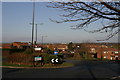
Ponteland Road from junction with Brunton Lane, Kingston Park
Image: © Phil Thirkell
Taken: 15 Nov 2003
0.17 miles
6
Newbiggin Dene at the back of Kenton Bank Heath
A footpath runs from Ponteland Road up the edge of Newbiggin Dene giving access to western side of Kenton Bank Heath estate.
Image: © Phil Thirkell
Taken: 4 Jan 2023
0.18 miles
7
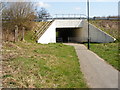
Subway under A696
Subway under the A696 from the Newbiggin Hall end leading to the path through Tudor Grange towards Bankfoot Metro. This picture is an update requested by Geograph for comments I made on an earlier picture of the same subway.
Image: © David Thornton
Taken: 16 Apr 2010
0.19 miles
8
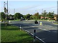
Roundabout at Tudor Way
At the junction with the B6918 Ponteland Road.
Image: © Thomas Nugent
Taken: 6 Oct 2008
0.19 miles
9
Subway under the A696
Path passing under the Newcastle to Jedburgh road.
Image: © Oliver Dixon
Taken: 1 Feb 2013
0.19 miles
10
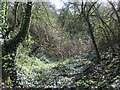
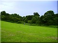
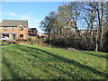
Old quarry west of Wilmington Court
This is a very overgrown triangular piece of ground between Wilmington Court on the east and Velville Court on the west. Unfortunately it was too overgrown to explore properly.
The location is shown on the 2nd edition of the OS map (revised in 1894) as "old quarry". On the 1st edition OS map (surveyed 1858) it is shown as the location of "Blood House". I haven't been able to find any information about Blood House or the quarry.
Image: © Phil Thirkell
Taken: 25 Mar 2019
0.19 miles