IMAGES TAKEN NEAR TO
York Avenue, JARROW, NE32 5XZ
Introduction
This page details the photographs taken nearby to York Avenue, NE32 5XZ by members of the Geograph project.
The Geograph project started in 2005 with the aim of publishing, organising and preserving representative images for every square kilometre of Great Britain, Ireland and the Isle of Man.

There are currently over 7.5m images from over14,400 individuals and you can help contribute to the project by visiting https://www.geograph.org.uk
Image Map (Loading...)


Getting Data...Please wait
Leaflet Map data © OpenStreetMap
Images are licensed for reuse under creativecommons.org/licenses/by-sa/2.0
Notes
- Clicking on the map will re-center to the selected point.
- The higher the marker number, the further away the image location is from the centre of the postcode.
Image Listing (6 Images Found)
Images are licensed for reuse under creativecommons.org/licenses/by-sa/2.0
Image
Details
Distance
3
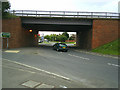
Flyover at Calf Close Lane in Jarrow
Looking from Calf Close Lane under the Flyover to the York Avenue Garage
Image: © Vin Mullen
Taken: 15 Oct 2005
0.07 miles
4
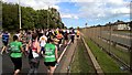
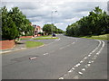
Uphill again on Great North Run
But approaching 7 miles
Image: © Chris Morgan
Taken: 11 Sep 2016
0.14 miles
5
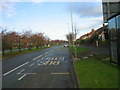
Roman Road in Jarrow
Roman Road looking from Brancepeth Terrace in Jarrow
Image: © Vin Mullen
Taken: 1 Jan 2008
0.17 miles
6
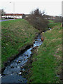
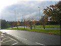
The Monkton Burn
The burn runs through the Monkton area of Jarrow
Image: © Chris Tweedy
Taken: 17 Jan 2006
0.19 miles