IMAGES TAKEN NEAR TO
Hill Park Road, JARROW, NE32 5XT
Introduction
This page details the photographs taken nearby to Hill Park Road, NE32 5XT by members of the Geograph project.
The Geograph project started in 2005 with the aim of publishing, organising and preserving representative images for every square kilometre of Great Britain, Ireland and the Isle of Man.

There are currently over 7.5m images from over14,400 individuals and you can help contribute to the project by visiting https://www.geograph.org.uk
Image Map (Loading...)


Getting Data...Please wait
Leaflet Map data © OpenStreetMap
Images are licensed for reuse under creativecommons.org/licenses/by-sa/2.0
Notes
- Clicking on the map will re-center to the selected point.
- The higher the marker number, the further away the image location is from the centre of the postcode.
Image Listing (128 Images Found)
Images are licensed for reuse under creativecommons.org/licenses/by-sa/2.0
Image
Details
Distance
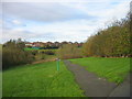
2
Causeway by the River Don
A narrow corridor of nature in an urban landscape, although there is rubbish and detritus blocking some of this waterway. The map indicates a hospital above the bank on the right
Image: © Chris Heaton
Taken: 23 Jan 2007
0.07 miles
3
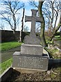
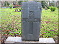
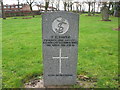
Commonwealth War Grave in Jarrow Cemetery (WW1-23)
Herbert Lowther Jennings.
Viewed on picture looking West.
This is a Commonwealth War Grave and Family Grave.
His younger brother Eric Kingsley Jennings was one of the fallen and is commemorated on this grave.
This grave, its headstone and surround are in a bad state of disrepair.
The Commonwealth War Graves Commission say it is the responsibility of the family or South Tyneside Council.
This has been brought to the attention of South Tyneside Council
http://www.cwgc.org/
Image: © Vin Mullen
Taken: 27 Jan 2007
0.08 miles
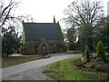
4
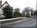
Jarrow Cemetery
Jarrow Cemetery entrance viewed from Cemetery Road
Image: © Vin Mullen
Taken: 1 Feb 2006
0.09 miles
5
Commonwealth War Grave in Jarrow Cemetery (WW1-27)
William Matthews.
Viewed on picture looking West.
http://www.cwgc.org/
Image: © Vin Mullen
Taken: 26 Jan 2007
0.09 miles
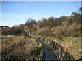
7
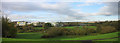
River Don Valley, Jarrow
New Jarrow School in the background
Image: © Les Hull
Taken: 9 Nov 2009
0.11 miles
8
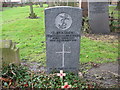
Commonwealth War Grave in Jarrow Cemetery (WW1-34)
Charles Peacock.
Viewed on picture looking West.
http://www.cwgc.org/
Image: © Vin Mullen
Taken: 26 Jan 2007
0.11 miles
9
Commonwealth War Grave in Jarrow Cemetery (WW1-42)
Thomas Edward Smith.
Viewed on picture looking West.
http://www.cwgc.org/
Image: © Vin Mullen
Taken: 26 Jan 2007
0.11 miles
10
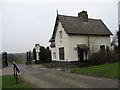
Jarrow Cemetery
Jarrow Cemetery entrance viewed from inside the Cemetery.
Showing the gates and the old Superintendants house.
To the left on the picture is a plaque of the plan of the Cemetery
Image: © Vin Mullen
Taken: 1 Feb 2006
0.11 miles