IMAGES TAKEN NEAR TO
Stephen Court, JARROW, NE32 5XF
Introduction
This page details the photographs taken nearby to Stephen Court, NE32 5XF by members of the Geograph project.
The Geograph project started in 2005 with the aim of publishing, organising and preserving representative images for every square kilometre of Great Britain, Ireland and the Isle of Man.

There are currently over 7.5m images from over14,400 individuals and you can help contribute to the project by visiting https://www.geograph.org.uk
Image Map (Loading...)


Getting Data...Please wait
Leaflet Map data © OpenStreetMap
Images are licensed for reuse under creativecommons.org/licenses/by-sa/2.0
Notes
- Clicking on the map will re-center to the selected point.
- The higher the marker number, the further away the image location is from the centre of the postcode.
Image Listing (103 Images Found)
Images are licensed for reuse under creativecommons.org/licenses/by-sa/2.0
Image
Details
Distance
1
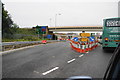
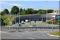
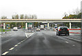
Junction of the A19 with the A185
The traffic is queuing for the Tyne Tunnel, which is undergoing construction works to expand the capacity. The first bridge here carries a railway.
Image: © Bill Boaden
Taken: 16 Sep 2011
0.09 miles
2
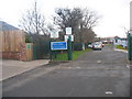
Epinay School and Clervaux Nursery in Jarrow
Epinay School and Clervaux Nursery in Clervaux Terrace in Jarrow
Image: © Vin Mullen
Taken: 27 Nov 2009
0.09 miles
3
Epinay and Clervaux Nursery in Jarrow
Epinay and Clervaux Nursery in Clervaux Terrace in Jarrow
Image: © Vin Mullen
Taken: 27 Nov 2009
0.09 miles
4
Approaching the Tyne Tunnel at Jarrow
The Tyne Tunnel is the furthest downstream fixed crossing of the River Tyne and is part of the A19.
The original project consisted of a set of foot and cycle tunnels, opened in 1951, and a single carriageway road tunnel, which opened in 1967. The tunnel became a severe bottleneck during the 1980s and 1990s, and, in 2004, it was decided to build a second parallel tunnel. Construction started in 2008 and opened in early 2011. Traffic started using both tunnels and hence the route became dual carriageway in late 2011 (https://www.sabre-roads.org.uk/wiki/index.php?title=Tyne_Tunnel SABRE).
Image: © David Dixon
Taken: 29 Apr 2019
0.11 miles
6
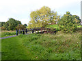
Footbridge over the River Don
A tranquil scene in the shadow of the A19. The River Don Path and Bedes Way runs up the River Don for 6 miles from the River Tyne at Jarrow to West Boldon; Bedes Way continues to the sea at Monkwearmouth
Image: © Oliver Dixon
Taken: 30 Sep 2015
0.12 miles
7
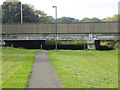
The River Don Path and the A19.
The River Don Path runs up the River Don for 6 miles from the River Tyne at Jarrow to West Boldon. Here it passes under the A19 with not a great deal of headroom!
Image: © Oliver Dixon
Taken: 30 Sep 2015
0.12 miles
8
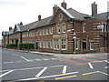
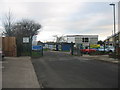
Police Station in Jarrow
The old Police Station on the corner of Clervaux Terrace and Monkton Road in Jarrow.
It no longer functions as a community Police station.
Image: © Vin Mullen
Taken: 7 Apr 2007
0.12 miles
9
Exit from the Tyne Tunnel
Heading south on the A19.
Image: © Pauline E
Taken: 26 Oct 2012
0.13 miles
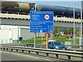
10
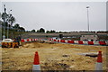
Roadworks by the Tyne Tunnel
The road descending is a link road from the A185.
Image: © Bill Boaden
Taken: 16 Sep 2011
0.13 miles