IMAGES TAKEN NEAR TO
Teviot Way, JARROW, NE32 5SJ
Introduction
This page details the photographs taken nearby to Teviot Way, NE32 5SJ by members of the Geograph project.
The Geograph project started in 2005 with the aim of publishing, organising and preserving representative images for every square kilometre of Great Britain, Ireland and the Isle of Man.

There are currently over 7.5m images from over14,400 individuals and you can help contribute to the project by visiting https://www.geograph.org.uk
Image Map (Loading...)


Getting Data...Please wait
Leaflet Map data © OpenStreetMap
Images are licensed for reuse under creativecommons.org/licenses/by-sa/2.0
Notes
- Clicking on the map will re-center to the selected point.
- The higher the marker number, the further away the image location is from the centre of the postcode.
Image Listing (36 Images Found)
Images are licensed for reuse under creativecommons.org/licenses/by-sa/2.0
Image
Details
Distance
1
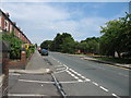
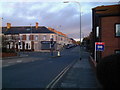
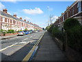
Bede Burn Road Jarrow
Bede Burn Road, Jarrow looking north east.
Image: © Vin Mullen
Taken: 23 May 2007
0.09 miles
2
Bede Burn Road, Jarrow
'Bede Burn Centre', Bede Burn Road, Jarrow.
Image: © Vin Mullen
Taken: 30 May 2008
0.10 miles
4
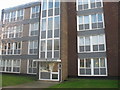
Marlborough Court Jarrow
Marlborough Court Bede Burn Road Jarrow
Image: © Vin Mullen
Taken: 14 Nov 2009
0.10 miles
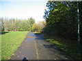
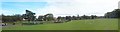
5
Park Road/Albert Road Junction
Junction to the South of Jarrows Centre.
Image: © MSX
Taken: 12 Nov 2005
0.10 miles
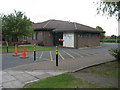
7
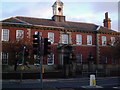
Bede's Club
Former government building now used for hosting functions.
Image: © MSX
Taken: 12 Nov 2005
0.10 miles
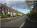
9
Bede Burn Road Jarrow
Bede Burn Road Jarrow looking north west.
Image: © Vin Mullen
Taken: 3 May 2009
0.12 miles
10
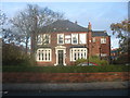
Henry Studdy House Jarrow
Henry Studdy House Bede Burn Road Jarrow
Taken from Field Terrace
Image: © Vin Mullen
Taken: 14 Nov 2009
0.13 miles