IMAGES TAKEN NEAR TO
Penshaw View, JARROW, NE32 5RD
Introduction
This page details the photographs taken nearby to Penshaw View, NE32 5RD by members of the Geograph project.
The Geograph project started in 2005 with the aim of publishing, organising and preserving representative images for every square kilometre of Great Britain, Ireland and the Isle of Man.

There are currently over 7.5m images from over14,400 individuals and you can help contribute to the project by visiting https://www.geograph.org.uk
Image Map (Loading...)


Getting Data...Please wait
Leaflet Map data © OpenStreetMap
Images are licensed for reuse under creativecommons.org/licenses/by-sa/2.0
Notes
- Clicking on the map will re-center to the selected point.
- The higher the marker number, the further away the image location is from the centre of the postcode.
Image Listing (6 Images Found)
Images are licensed for reuse under creativecommons.org/licenses/by-sa/2.0
Image
Details
Distance
1
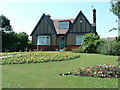
Jarvis Park in Jarrow
Old Parkeeper's cottage at the Butchers Bridge entrance to Jarvis Park in Primrose, Jarrow
The park is known to others? as:
Monkton Dene Park
Valley View Park
Primrose Park
Image: © Vin Mullen
Taken: 4 Jul 2003
0.13 miles
2
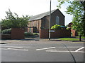
St. Matthew?s RC Church in Jarrow
St. Matthew’s RC Church in Jarrow at the junction of Butchers Bridge Road and York Avenue
Image: © Vin Mullen
Taken: 3 May 2007
0.16 miles
3
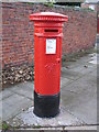
Victorian postbox, Bede Burn Road / Dillon Street
Image: © Mike Quinn
Taken: 3 Nov 2009
0.21 miles
4
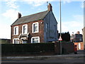
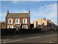
The (former) School House, Bede Burn Road / Dillon Street
Shows the location of Image
Image: © Mike Quinn
Taken: 3 Nov 2009
0.22 miles
6
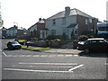
Bede Terrace Jarrow
Bede Terrace at the junction of Springwell Terrace in Jarrow looking east
Image: © Vin Mullen
Taken: 3 May 2007
0.23 miles